IMAGES TAKEN NEAR TO
Ivy Lodge Road, COLCHESTER, CO6 4EW
Introduction
This page details the photographs taken nearby to Ivy Lodge Road, CO6 4EW by members of the Geograph project.
The Geograph project started in 2005 with the aim of publishing, organising and preserving representative images for every square kilometre of Great Britain, Ireland and the Isle of Man.

There are currently over 7.5m images from over14,400 individuals and you can help contribute to the project by visiting https://www.geograph.org.uk
Image Map (Loading...)


Getting Data...Please wait
Leaflet Map data © OpenStreetMap
Images are licensed for reuse under creativecommons.org/licenses/by-sa/2.0
Notes
- Clicking on the map will re-center to the selected point.
- The higher the marker number, the further away the image location is from the centre of the postcode.
Image Listing (5 Images Found)
Images are licensed for reuse under creativecommons.org/licenses/by-sa/2.0
Image
Details
Distance
1
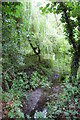
Black Brook
The Essex Way runs north beside the brook from Ivy Lodge Road.
Image: © John Myers
Taken: 12 Aug 2010
0.19 miles
2
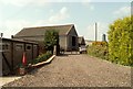
Part of Woodside Farm on Horkesley Road
Image: © Robert Edwards
Taken: 9 Jun 2008
0.20 miles
3
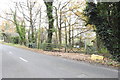
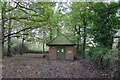
Sewage pumping station enclosure at Great Horkesley
Image: © Adrian S Pye
Taken: 21 Nov 2019
0.20 miles
4
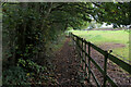
Essex Way having left Ivy Lodge Road
The long distance footpath just after leaving Ivy Lodge Road, following a strip of woodland
Image: © Chris Heaton
Taken: 15 Oct 2020
0.20 miles
5
Sewage pumping station, Ivy Lodge Road, Great Horkesley
Image: © Tim Heaton
Taken: 15 Oct 2020
0.20 miles