IMAGES TAKEN NEAR TO
School Lane, COLCHESTER, CO6 4DN
Introduction
This page details the photographs taken nearby to School Lane, CO6 4DN by members of the Geograph project.
The Geograph project started in 2005 with the aim of publishing, organising and preserving representative images for every square kilometre of Great Britain, Ireland and the Isle of Man.

There are currently over 7.5m images from over14,400 individuals and you can help contribute to the project by visiting https://www.geograph.org.uk
Image Map
Images are licensed for reuse under creativecommons.org/licenses/by-sa/2.0
Notes
- Clicking on the map will re-center to the selected point.
- The higher the marker number, the further away the image location is from the centre of the postcode.
Image Listing (16 Images Found)
Images are licensed for reuse under creativecommons.org/licenses/by-sa/2.0
Image
Details
Distance
1
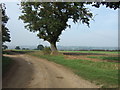
Byway North of Little Horkesley
Byway out of Little Horkesley looking towards the Stour Valley
Image: © David Sanderson
Taken: 17 Oct 2006
0.03 miles
2
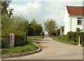
The start of a byway known as School Lane
School Road is in the foreground.
Image: © Robert Edwards
Taken: 2 May 2008
0.06 miles
3
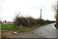
School Road, Horkesley from the entrance to Hall Farm
Recent rainfall caused the pond (unseen on the right) to overflow and flood the road.
Image: © Adrian S Pye
Taken: 21 Nov 2019
0.08 miles
4
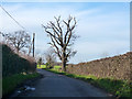
School Road, Little Horkesley
Leaving the village to the west.
Image: © Robin Webster
Taken: 13 Jan 2016
0.12 miles
5
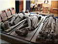
The wooden effigies inside St. Peter & St. Paul's church
The parish church at Little Horkesley was completed destroyed by a bomb in September 1940. These three oak effigies were salvaged from the ruin and placed here in the church that was rebuilt in 1958. The effigy on the left and the one in the middle are of knights and date back to mid 13th century. The effigy on the right is of a lady and dates back to the late 13th century.
Image: © Robert Edwards
Taken: 4 Jul 2008
0.17 miles
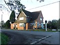
6
The Beehive Inn
The Beehive Inn public house at Little Horkesley, Essex. For other view see http://www.geograph.org.uk/photo/3743591
Image: © Keith Evans
Taken: 14 Nov 2013
0.19 miles
7
The Beehive Inn
The Beehive Inn public house at Little Horkesley, Essex. For other view see http://www.geograph.org.uk/photo/3743584
Image: © Keith Evans
Taken: 14 Nov 2013
0.19 miles
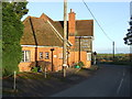
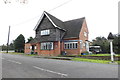
8
The Beehive, Little Horkesley
On the corner of School Road and Nayland Road.
Image: © Robin Webster
Taken: 13 Jan 2016
0.19 miles
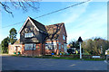
9
The Beehive public house, Little Horkesley
https://www.geograph.org.uk/photo/6325998
Image: © Adrian S Pye
Taken: 21 Nov 2019
0.19 miles
10
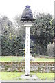
The sign of The Beehive public house
https://www.geograph.org.uk/photo/6325996
Image: © Adrian S Pye
Taken: 21 Nov 2019
0.19 miles