IMAGES TAKEN NEAR TO
Coach Road, COLCHESTER, CO6 4AX
Introduction
This page details the photographs taken nearby to Coach Road, CO6 4AX by members of the Geograph project.
The Geograph project started in 2005 with the aim of publishing, organising and preserving representative images for every square kilometre of Great Britain, Ireland and the Isle of Man.

There are currently over 7.5m images from over14,400 individuals and you can help contribute to the project by visiting https://www.geograph.org.uk
Image Map
Images are licensed for reuse under creativecommons.org/licenses/by-sa/2.0
Notes
- Clicking on the map will re-center to the selected point.
- The higher the marker number, the further away the image location is from the centre of the postcode.
Image Listing (4 Images Found)
Images are licensed for reuse under creativecommons.org/licenses/by-sa/2.0
Image
Details
Distance
1
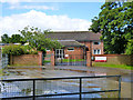
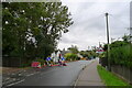
Bishop William Ward Primary School
The nameplate describes the school as being in Great Horkesley, presumably that is the parish, as the actual area here is Horkesley Heath.
Image: © Robin Webster
Taken: 2 Jul 2016
0.17 miles
2
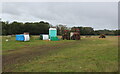
Tractors and Portaloos
Field just off the Essex Way dedicated to portaloos - both in the horizontal and vertical, with a smattering of tractors.
Image: © Chris Heaton
Taken: 15 Oct 2020
0.18 miles
3
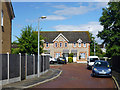
Houses, Keelers Way, Horkesley Heath
On a short dead-end off the main dead-end.
Image: © Robin Webster
Taken: 2 Jul 2016
0.19 miles