IMAGES TAKEN NEAR TO
New Road, COLCHESTER, CO6 3QT
Introduction
This page details the photographs taken nearby to New Road, CO6 3QT by members of the Geograph project.
The Geograph project started in 2005 with the aim of publishing, organising and preserving representative images for every square kilometre of Great Britain, Ireland and the Isle of Man.

There are currently over 7.5m images from over14,400 individuals and you can help contribute to the project by visiting https://www.geograph.org.uk
Image Map
Images are licensed for reuse under creativecommons.org/licenses/by-sa/2.0
Notes
- Clicking on the map will re-center to the selected point.
- The higher the marker number, the further away the image location is from the centre of the postcode.
Image Listing (20 Images Found)
Images are licensed for reuse under creativecommons.org/licenses/by-sa/2.0
Image
Details
Distance
1
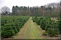
Christmas Tree Crop
Clearly the nearby garden centre grows its own.
Image: © Glyn Baker
Taken: 22 Mar 2019
0.07 miles
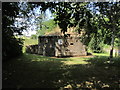
2
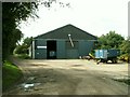
Farm building near Aldham, Essex
The sign on this building says Wick Farm Ltd., but there doesn't appear to be a farm closeby with that name.
Image: © Robert Edwards
Taken: 30 Aug 2006
0.07 miles
3
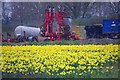
Field of Daffs
I assume the crop in this field is for bulbs as the flowers appear to be far too open for the cut flower market.
Image: © Glyn Baker
Taken: 22 Mar 2019
0.08 miles
4
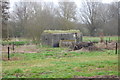
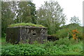
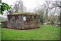
The Essex Way 108 - pillbox
This pillbox, one of many along this section of the Colne Valley, stands close by the river.
Image: © Trevor Harris
Taken: 13 Mar 2011
0.10 miles
5
Mill Race pillbox
A type FW3/22 erected as part of the Eastern Command Line. "The FW3/22 was designed to cater for five light machine guns, one rifle, and six men." [Information from notice board].
Image: © Tim Heaton
Taken: 14 Oct 2020
0.11 miles
6
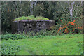
Mill Race Pillbox, Aldham
FW3/22 pillbox designated to cater for 5 light machine guns, one rifle and 6 men.
Originally they were manned by the Army, RAF, Navy and the Royal Marines - but later handed over to the Home Guard
Passed by on the Essex Way.
Image: © Chris Heaton
Taken: 14 Oct 2020
0.11 miles
7
Pill box & picnic area beside Mill Race Garden Centre, Fordstreet
Image: © Colin Park
Taken: 6 Jul 2015
0.11 miles
8
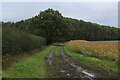
Muddy Track heading towards Ashington Grove
Private track leading off the Essex Way
Image: © Chris Heaton
Taken: 14 Oct 2020
0.12 miles
9
Type 22 Pillbox
The interpretation board calls this the Mill Race Pill Box. For more information about types of pill boxes visit http://www.pillboxesuk.co.uk/
Image: © Glyn Baker
Taken: 22 Mar 2019
0.12 miles
10
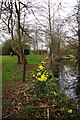
Mill Race and the Essex Way
The path to the left is the Essex Way https://www.ldwa.org.uk/ldp/members/show_path.php?path_name=Essex+Way . The Mill Race is a canalised section of the River Colne leading to Fordstreet.
In the distance you can see a landing stage for pleasure boats and a Image
Image: © Glyn Baker
Taken: 22 Mar 2019
0.13 miles