IMAGES TAKEN NEAR TO
White Colne, COLCHESTER, CO6 2QH
Introduction
This page details the photographs taken nearby to CO6 2QH by members of the Geograph project.
The Geograph project started in 2005 with the aim of publishing, organising and preserving representative images for every square kilometre of Great Britain, Ireland and the Isle of Man.

There are currently over 7.5m images from over14,400 individuals and you can help contribute to the project by visiting https://www.geograph.org.uk
Image Map (Loading...)


Getting Data...Please wait
Leaflet Map data © OpenStreetMap
Images are licensed for reuse under creativecommons.org/licenses/by-sa/2.0
Notes
- Clicking on the map will re-center to the selected point.
- The higher the marker number, the further away the image location is from the centre of the postcode.
Image Listing (3 Images Found)
Images are licensed for reuse under creativecommons.org/licenses/by-sa/2.0
Image
Details
Distance
1
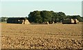
Bures Field, Bramble Farm
Straw bales after harvest.
Image: © Robert Edwards
Taken: 20 Sep 2006
0.06 miles
3
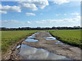
Potholed track
This is presumably a private farm track, but it does not say so. It is a through route to another lane.
Image: © Robin Webster
Taken: 1 Mar 2015
0.25 miles