IMAGES TAKEN NEAR TO
Tey Road, COLCHESTER, CO6 2LG
Introduction
This page details the photographs taken nearby to Tey Road, CO6 2LG by members of the Geograph project.
The Geograph project started in 2005 with the aim of publishing, organising and preserving representative images for every square kilometre of Great Britain, Ireland and the Isle of Man.

There are currently over 7.5m images from over14,400 individuals and you can help contribute to the project by visiting https://www.geograph.org.uk
Image Map
Images are licensed for reuse under creativecommons.org/licenses/by-sa/2.0
Notes
- Clicking on the map will re-center to the selected point.
- The higher the marker number, the further away the image location is from the centre of the postcode.
Image Listing (43 Images Found)
Images are licensed for reuse under creativecommons.org/licenses/by-sa/2.0
Image
Details
Distance
1
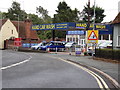
Hand Car Wash on the A1124 Lower Holt Street
Image: © Geographer
Taken: 29 Jul 2018
0.07 miles
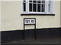
2
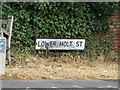
Lower Holt Street sign
On the A1124 Lower Holt Street at the junction with the A1124 Upper Holt Street & Tey Road
Image: © Geographer
Taken: 29 Jul 2018
0.09 miles
3
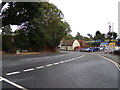
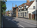
A1124 Lower Holt Street, Earls Colne
At the junction with the A1124 Upper Holt Street & Tey Road
Image: © Geographer
Taken: 29 Jul 2018
0.09 miles
4
Tey Road, Earls Colne
At the junction with the A1124 Lower Holt Street & A1124 Upper Holt Street
Image: © Geographer
Taken: 29 Jul 2018
0.09 miles
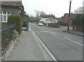
5
A1124 Lower Holt Street, Earls Colne
At the junction with Tey Road & A1124 Upper Holt Street
Image: © Geographer
Taken: 18 Aug 2018
0.09 miles
6
Tey Road sign
On Tey Road at the junction with the A1124 Lower Holt Street & A1124 Upper Holt Street
Image: © Geographer
Taken: 29 Jul 2018
0.09 miles
7
Looking east-northeast along Upper Holt Street
On the right is Oxford House at numbers 17 & 19, which is a grade II listed building dating from the 14th century, late 15th and 18th centuries. It was altered in the early 19th century. It is timber framed clad with red brick in Flemish bond, with handmade red plain tiles on the roof http://www.britishlistedbuildings.co.uk/en-115918-oxford-house-earls-colne-essex This view shows that the walls have been painted white. It appears from this http://www.useyourlocal.com/pubs/essex/colchester/earls-colne/oxford-house/q/ref-2082/ that it was a public house, which has since closed.
Image: © John Baker
Taken: 29 Mar 2014
0.10 miles
8
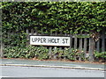
Upper Holt Street sign
On the A1124 Upper Holt Street at the junction with the A1124 Lower Holt Street & Tey Road
Image: © Geographer
Taken: 29 Jul 2018
0.10 miles
9
Lower Holt Street, Earls Colne (listed buildings)
Lower Holt Street contains a number of listed buildings. Close to the camera is No. 14 List entry Number: 1337927 http://list.english-heritage.org.uk/resultsingle.aspx?uid=1337927 . The building with the exposed timber frame is No. 20 List entry Number: 1123194: http://list.english-heritage.org.uk/resultsingle.aspx?uid=1123194 .
Image: © Roger Jones
Taken: 18 May 2014
0.10 miles
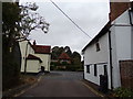
10
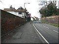
Looking southwest along Lower Holt Street
The nearest house is number 28.
Image: © John Baker
Taken: 29 Mar 2014
0.11 miles