IMAGES TAKEN NEAR TO
Elms Hall Road, COLCHESTER, CO6 2JL
Introduction
This page details the photographs taken nearby to Elms Hall Road, CO6 2JL by members of the Geograph project.
The Geograph project started in 2005 with the aim of publishing, organising and preserving representative images for every square kilometre of Great Britain, Ireland and the Isle of Man.

There are currently over 7.5m images from over14,400 individuals and you can help contribute to the project by visiting https://www.geograph.org.uk
Image Map
Images are licensed for reuse under creativecommons.org/licenses/by-sa/2.0
Notes
- Clicking on the map will re-center to the selected point.
- The higher the marker number, the further away the image location is from the centre of the postcode.
Image Listing (3 Images Found)
Images are licensed for reuse under creativecommons.org/licenses/by-sa/2.0
Image
Details
Distance
1

Elms Hall Road
This follows the River Colne to the left, at a comfortable remove up the valley slope.
Image: © Robin Webster
Taken: 15 Feb 2015
0.11 miles
2
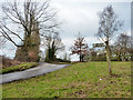
Triangular junction near Langley Mill
The third arm to the signpost on the triangle, pointing right, has gone missing. It would have pointed to Colne Engaine.
Image: © Robin Webster
Taken: 15 Feb 2015
0.12 miles
3
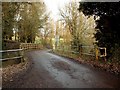
Bridge on Elms Hall Road
This bridge stands over the river Colne by Langley Mill.
Image: © Robert Edwards
Taken: 28 Dec 2006
0.21 miles