IMAGES TAKEN NEAR TO
Colne Engaine, COLCHESTER, CO6 2HW
Introduction
This page details the photographs taken nearby to CO6 2HW by members of the Geograph project.
The Geograph project started in 2005 with the aim of publishing, organising and preserving representative images for every square kilometre of Great Britain, Ireland and the Isle of Man.

There are currently over 7.5m images from over14,400 individuals and you can help contribute to the project by visiting https://www.geograph.org.uk
Image Map (Loading...)


Getting Data...Please wait
Leaflet Map data © OpenStreetMap
Images are licensed for reuse under creativecommons.org/licenses/by-sa/2.0
Notes
- Clicking on the map will re-center to the selected point.
- The higher the marker number, the further away the image location is from the centre of the postcode.
Image Listing (4 Images Found)
Images are licensed for reuse under creativecommons.org/licenses/by-sa/2.0
Image
Details
Distance
1
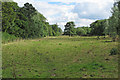
Public footpath and field off Overhall Hill, Colne Engaine
Footpath on right hand side of pic.
Image: © Roger Jones
Taken: 3 Jul 2016
0.13 miles
2
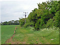
Track along field edge
An East Anglian Farm Ride route (for horses). " For an small annual fee, horse riders are able to ride on ALL routes managed by E.A.F.R."
Image: © Robin Webster
Taken: 21 May 2016
0.14 miles
3
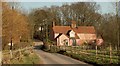
Country lane, east of Colne Engaine, Essex
The road from Colne Engaine to Countess Cross.
Image: © Robert Edwards
Taken: 15 Mar 2006
0.14 miles
4
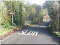
Slow Road Narrows
Minor road scene near to Countless Cross, Essex.
Image: © Keith Evans
Taken: 17 Jan 2017
0.18 miles