IMAGES TAKEN NEAR TO
Boarded Barn Road, COLCHESTER, CO6 2AU
Introduction
This page details the photographs taken nearby to Boarded Barn Road, CO6 2AU by members of the Geograph project.
The Geograph project started in 2005 with the aim of publishing, organising and preserving representative images for every square kilometre of Great Britain, Ireland and the Isle of Man.

There are currently over 7.5m images from over14,400 individuals and you can help contribute to the project by visiting https://www.geograph.org.uk
Image Map
Images are licensed for reuse under creativecommons.org/licenses/by-sa/2.0
Notes
- Clicking on the map will re-center to the selected point.
- The higher the marker number, the further away the image location is from the centre of the postcode.
Image Listing (4 Images Found)
Images are licensed for reuse under creativecommons.org/licenses/by-sa/2.0
Image
Details
Distance
1
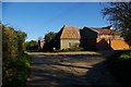
Norton Hall Farm
This is Norton Hall Farm to the North West of Colchester (marked on O.S 1:25,000 series as Boarded Barn)
Image: © Glyn Baker
Taken: 4 Nov 2006
0.06 miles
2
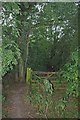
Gate to Thornwood
Image: © Glyn Baker
Taken: 8 Sep 2012
0.09 miles
3
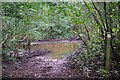
Damp Path in Thornfield Wood
Needless to say the right of way is honoured in the breach by most walkers judging by the well worn path around the pond.
Image: © Glyn Baker
Taken: 8 Sep 2012
0.17 miles
4
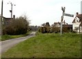
Road junction at Janke's Green
The road ahead leads to Wakes Colne Green.
Image: © Robert Edwards
Taken: 21 Apr 2008
0.24 miles