IMAGES TAKEN NEAR TO
St. Peters Road, COLCHESTER, CO6 1SR
Introduction
This page details the photographs taken nearby to St. Peters Road, CO6 1SR by members of the Geograph project.
The Geograph project started in 2005 with the aim of publishing, organising and preserving representative images for every square kilometre of Great Britain, Ireland and the Isle of Man.

There are currently over 7.5m images from over14,400 individuals and you can help contribute to the project by visiting https://www.geograph.org.uk
Image Map
Images are licensed for reuse under creativecommons.org/licenses/by-sa/2.0
Notes
- Clicking on the map will re-center to the selected point.
- The higher the marker number, the further away the image location is from the centre of the postcode.
Image Listing (39 Images Found)
Images are licensed for reuse under creativecommons.org/licenses/by-sa/2.0
Image
Details
Distance
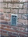
1
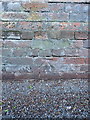
OS benchmark - Coggeshall, wall on west side St Peter's Road
An OS cutmark low on the wall bounding the roadside; originally levelled in 1972 at 36.544m above Ordnance Datum Newlyn.
Image: © Richard Law
Taken: 6 Apr 2016
0.06 miles
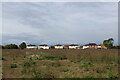
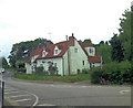
2
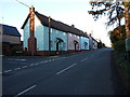
New cottages beside the Colchester Road
A terrace of recently-built cottages beside the main road out of Coggeshall.
Image: © Richard Law
Taken: 6 Apr 2016
0.11 miles
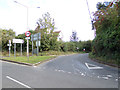
4
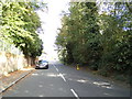
B1024 Colchester Road, Coggeshall
At the junction with Feering Road
Image: © Geographer
Taken: 5 Oct 2019
0.12 miles
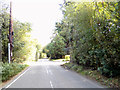
5
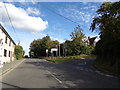
Feering Road, Coggeshall
At the junction with the B1024 Colchester Road
Image: © Geographer
Taken: 5 Oct 2019
0.12 miles
6
OS Flush Bracket - Coggeshall
Flush Bracket 11726 on the wall of a house on Colchester Road; originally levelled at 39.861m above Ordnance Datum Newlyn in 1972
Image: © Richard Law
Taken: 6 Apr 2016
0.13 miles
7

A Corner of Coggeshall Recreation Ground
The Essex Way passes through this recreation ground in Coggeshall.
Image: © Chris Heaton
Taken: 14 Oct 2020
0.16 miles
8
Feering Road, Coggeshall
Near the junction with the B1024 Colchester Road
Image: © Geographer
Taken: 5 Oct 2019
0.17 miles
9
Looking towards Tey Road from the Essex Way
Looking roughly north from the Essex Way long distance footpath as it takes leave of Coggeshall
Image: © Chris Heaton
Taken: 14 Oct 2020
0.17 miles
10
21, Church Green
This 17th C. house has later additions but is Grade II listed with English Heritage Building ID: 116062.
Image: © Stuart Logan
Taken: 23 Jun 2013
0.18 miles