IMAGES TAKEN NEAR TO
Barn View Road, COLCHESTER, CO6 1RF
Introduction
This page details the photographs taken nearby to Barn View Road, CO6 1RF by members of the Geograph project.
The Geograph project started in 2005 with the aim of publishing, organising and preserving representative images for every square kilometre of Great Britain, Ireland and the Isle of Man.

There are currently over 7.5m images from over14,400 individuals and you can help contribute to the project by visiting https://www.geograph.org.uk
Image Map
Images are licensed for reuse under creativecommons.org/licenses/by-sa/2.0
Notes
- Clicking on the map will re-center to the selected point.
- The higher the marker number, the further away the image location is from the centre of the postcode.
Image Listing (111 Images Found)
Images are licensed for reuse under creativecommons.org/licenses/by-sa/2.0
Image
Details
Distance
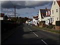
2
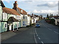
Bridge Street leads to Grange Hill
Grange Hill runs south from Coggeshall, and becomes the B1024 Kelvedon Road.
Image: © Richard Law
Taken: 6 Apr 2016
0.04 miles
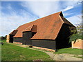
4
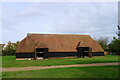
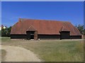
Grange Barn, Coggeshall
"... one of the oldest surviving timber-framed buildings in Europe." A 13th century 'tithe barn' serving the former Cistercian Abbey.
Image: © Tim Heaton
Taken: 14 Oct 2020
0.05 miles
6
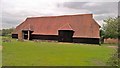
The Grange Barn, Coggeshall
Grade I listed building from 12th/13th Century but rebuilt, altered and restored , see; https://britishlistedbuildings.co.uk/101123112-the-grange-barn-coggeshall#.W4aoNLgnaUm
Image: © Chris Morgan
Taken: 28 Aug 2018
0.06 miles
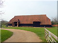
8
Grange Barn, Little Coggeshall, Essex
Grange Barn is open to the public and in the care of the National Trust. It was once part of Grange Farm. The barn was built in 1500, about 130ft long with a king-post roof. It has six bays, aisles, two porches and a huge tiled roof.
Image: © Robert Edwards
Taken: 14 Jun 2006
0.06 miles
9
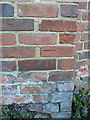
OS benchmark - Grange Hill, wall south of junction with Abbey Lane
An OS cutmark on the corner of a wall just west of the main B1024; originally levelled at 38.39m above Ordnance Datum Newlyn.
Image: © Richard Law
Taken: 6 Apr 2016
0.06 miles
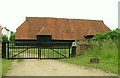
10

Coggeshall Grange Barn
A huge timber-framed barn managed by the National Trust
Image: © David Smith
Taken: 14 Jun 2014
0.06 miles