IMAGES TAKEN NEAR TO
Birch Road, COLCHESTER, CO6 1DR
Introduction
This page details the photographs taken nearby to Birch Road, CO6 1DR by members of the Geograph project.
The Geograph project started in 2005 with the aim of publishing, organising and preserving representative images for every square kilometre of Great Britain, Ireland and the Isle of Man.

There are currently over 7.5m images from over14,400 individuals and you can help contribute to the project by visiting https://www.geograph.org.uk
Image Map
Images are licensed for reuse under creativecommons.org/licenses/by-sa/2.0
Notes
- Clicking on the map will re-center to the selected point.
- The higher the marker number, the further away the image location is from the centre of the postcode.
Image Listing (5 Images Found)
Images are licensed for reuse under creativecommons.org/licenses/by-sa/2.0
Image
Details
Distance
1
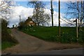
Bockingham Hall Footpath
This footpath runs from Bockingham Hall (behind the photographer) to a minor road to the northwest of Heckfordbridge
Image: © Glyn Baker
Taken: 17 Apr 2006
0.05 miles
2
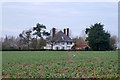
A view of Bockingham Hall Farm
This is the road between Hardy's Green and Copford.
Image: © Robert Edwards
Taken: 27 Feb 2008
0.10 miles
3
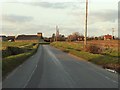
School Road, Claypit Green
At the junction with Fountain Lane
Image: © Geographer
Taken: 10 Sep 2016
0.12 miles
4

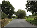
Southern end of Aldercar Road
Looking towards its junction with Fountain Lane.
Image: © Trevor Harris
Taken: 18 Apr 2016
0.16 miles