IMAGES TAKEN NEAR TO
Allendale Drive, COLCHESTER, CO6 1BP
Introduction
This page details the photographs taken nearby to Allendale Drive, CO6 1BP by members of the Geograph project.
The Geograph project started in 2005 with the aim of publishing, organising and preserving representative images for every square kilometre of Great Britain, Ireland and the Isle of Man.

There are currently over 7.5m images from over14,400 individuals and you can help contribute to the project by visiting https://www.geograph.org.uk
Image Map
Images are licensed for reuse under creativecommons.org/licenses/by-sa/2.0
Notes
- Clicking on the map will re-center to the selected point.
- The higher the marker number, the further away the image location is from the centre of the postcode.
Image Listing (7 Images Found)
Images are licensed for reuse under creativecommons.org/licenses/by-sa/2.0
Image
Details
Distance
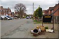
1
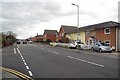
London Road Copford
Should I tag this as "Village" or "Suburb" it is a choice I suspect would gain me brickbats from Copfordian's whichever I plumped for!
Image: © Glyn Baker
Taken: 15 Mar 2019
0.10 miles
2
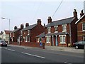
Copford Cop Shop
This ordinary looking Edwardian style villa on the B1408 is the home to Copford’s Community Policing project. In the old days it was just the “Police House”
Image: © Glyn Baker
Taken: 8 Oct 2005
0.10 miles
4
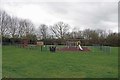
Copford Kiddies Play Area
Located off Queens Avenue
Image: © Glyn Baker
Taken: 15 Mar 2019
0.17 miles
6
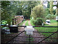
Copford Place
Copford place in woodland next to A12
Image: © David Sanderson
Taken: 18 Oct 2006
0.21 miles
7
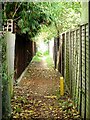
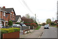
Footpath to Green Acres
This footpath runs from the B1408 in Copford to Green Acres near Eight Ash Green. At this point it runs between houses and gardens.
Image: © Glyn Baker
Taken: 8 Oct 2005
0.24 miles