IMAGES TAKEN NEAR TO
Longacres Hanover Square, COLCHESTER, CO5 9QP
Introduction
This page details the photographs taken nearby to Longacres Hanover Square, CO5 9QP by members of the Geograph project.
The Geograph project started in 2005 with the aim of publishing, organising and preserving representative images for every square kilometre of Great Britain, Ireland and the Isle of Man.

There are currently over 7.5m images from over14,400 individuals and you can help contribute to the project by visiting https://www.geograph.org.uk
Image Map (Loading...)


Getting Data...Please wait
Leaflet Map data © OpenStreetMap
Images are licensed for reuse under creativecommons.org/licenses/by-sa/2.0
Notes
- Clicking on the map will re-center to the selected point.
- The higher the marker number, the further away the image location is from the centre of the postcode.
Image Listing (16 Images Found)
Images are licensed for reuse under creativecommons.org/licenses/by-sa/2.0
Image
Details
Distance
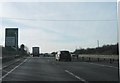
2
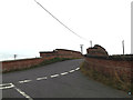
Hanover Bridge on New Lane
At the junction with The Street
Image: © Geographer
Taken: 10 Sep 2016
0.15 miles
3
The Street, Feering
At the junction with New Lane at Hanover Bridge
Image: © Geographer
Taken: 10 Sep 2016
0.15 miles
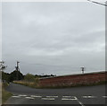
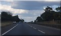
6
Speed camera on A12
On the Kelvedon - Marks Tey stretch.
Image: © Robin Webster
Taken: 7 Feb 2016
0.21 miles
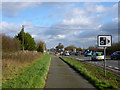
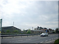
7
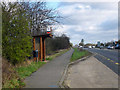
New Lane bus stop, Feering
On the slip road from the old Roman route through Kelvedon just before it is rejoined by the A12 Kelvedon bypass.
Image: © Robin Webster
Taken: 7 Feb 2016
0.22 miles
8
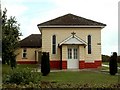
Feering Evangelical Church, Feering, Essex
This church stands in a part of Feering called Stocks Green.
Image: © Robert Edwards
Taken: 28 Aug 2006
0.22 miles
10
Prested Hall Farm
See from the north-bound carriageway of the A12.
Image: © Andy Potter
Taken: 10 Apr 2009
0.23 miles