IMAGES TAKEN NEAR TO
Barnfield, COLCHESTER, CO5 9HP
Introduction
This page details the photographs taken nearby to Barnfield, CO5 9HP by members of the Geograph project.
The Geograph project started in 2005 with the aim of publishing, organising and preserving representative images for every square kilometre of Great Britain, Ireland and the Isle of Man.

There are currently over 7.5m images from over14,400 individuals and you can help contribute to the project by visiting https://www.geograph.org.uk
Image Map
Images are licensed for reuse under creativecommons.org/licenses/by-sa/2.0
Notes
- Clicking on the map will re-center to the selected point.
- The higher the marker number, the further away the image location is from the centre of the postcode.
Image Listing (33 Images Found)
Images are licensed for reuse under creativecommons.org/licenses/by-sa/2.0
Image
Details
Distance
1
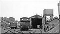
Kelvedon (Low Level) engine shed, 1950
View SW, with Kelvedon Low Level station (terminus of the Light Railway from Tollesbury Pier) being adjacent to the right. The depot was closed 5/5/51 along with the passenger service, but freight continued until 28/9/62. The locomotive is an ex-GER J67 0-6-0T.
Image: © Walter Dendy, deceased
Taken: 7 Aug 1950
0.03 miles
2
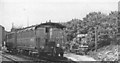
Kelvedon (Low Level) station, 1950
View SW towards buffers, the High Level station being beyond and above. The coaches, with glazed end-vestibule, are (probably)[?] from the former Wisbech & Upwell Tramway, the service from Tollesbury being still in operation: it ceased from 7/5/51, goods from 29/10/51 (from Tiptree from 28/9/62).
Image: © Walter Dendy, deceased
Taken: 7 Aug 1950
0.11 miles
3
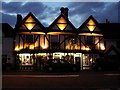
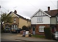
The Sun Inn, Feering Hill, Essex
The Sun Inn was originally part of a 16th Century Gentleman's residence known as "Feering House" dating from 1525. It stands on the old roman road from London to Colchester.
Image: © Robert Edwards
Taken: 1 Sep 2005
0.12 miles
4
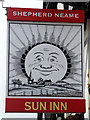
Inn sign, Sun Inn, Feering
For the rest of the pub, see Image
Image: © Robin Webster
Taken: 15 Feb 2015
0.12 miles
5
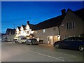
Houses on Feering Road, Kelvedon
The top halves of the houses on the right were yellow and blue when captured in 2009
Image: © David Howard
Taken: 4 Apr 2017
0.12 miles
6
The Sun Inn, Feering
A Shepherd Neame house.
Image: © Robin Webster
Taken: 15 Feb 2015
0.12 miles
8
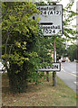
Roadsign & Kelvedon Village Name sign
On the B1024 Ferring Hill at the junction with Worlds End Lane
Image: © Geographer
Taken: 10 Sep 2016
0.13 miles
9
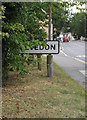
Kelvedon Village Name sign on the B1024 Feering Hill
At the junction with Worlds End Lane
Image: © Geographer
Taken: 10 Sep 2016
0.13 miles
10
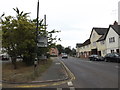
Entering Kelvedon on the B1024 Feering Hill
At the junction with Worlds End Lane
Image: © Geographer
Taken: 10 Sep 2016
0.13 miles