IMAGES TAKEN NEAR TO
Church Hill, COLCHESTER, CO5 9BY
Introduction
This page details the photographs taken nearby to Church Hill, CO5 9BY by members of the Geograph project.
The Geograph project started in 2005 with the aim of publishing, organising and preserving representative images for every square kilometre of Great Britain, Ireland and the Isle of Man.

There are currently over 7.5m images from over14,400 individuals and you can help contribute to the project by visiting https://www.geograph.org.uk
Image Map
Images are licensed for reuse under creativecommons.org/licenses/by-sa/2.0
Notes
- Clicking on the map will re-center to the selected point.
- The higher the marker number, the further away the image location is from the centre of the postcode.
Image Listing (45 Images Found)
Images are licensed for reuse under creativecommons.org/licenses/by-sa/2.0
Image
Details
Distance

2
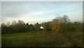
Kelvedon: looking off the railway towards houses on Hollow Road
Image: © Christopher Hilton
Taken: 9 Nov 2017
0.08 miles
3
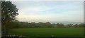
Kelvedon: fields off the railway line, at the level crossing
Image: © Christopher Hilton
Taken: 9 Nov 2017
0.11 miles
4
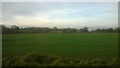
Kelvedon: fields north-west of the railway, from the train
Image: © Christopher Hilton
Taken: 9 Nov 2017
0.12 miles
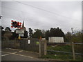
5
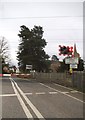
Level crossing on Church Street, Kelvedon
St Mary's Church is on the right
Image: © David Howard
Taken: 4 Apr 2017
0.13 miles
6
Level crossing on Church Street, Kelvedon
Image: © David Howard
Taken: 4 Apr 2017
0.13 miles
7

Kelvedon: Looking south west from the railway level crossing
Image: © Michael Garlick
Taken: 21 Aug 2018
0.14 miles
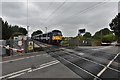
8

The level crossing at Kelvedon
St. Mary's church is just on the right of the picture.
Image: © Robert Edwards
Taken: 25 Jan 2008
0.14 miles
10
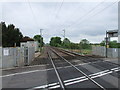
Railway line crossing Church Street Kelvedon
The picture is taken looking in the direction of London (Liverpool Street)
Image: © PAUL FARMER
Taken: 31 May 2010
0.15 miles