IMAGES TAKEN NEAR TO
Church Road, COLCHESTER, CO5 9AS
Introduction
This page details the photographs taken nearby to Church Road, CO5 9AS by members of the Geograph project.
The Geograph project started in 2005 with the aim of publishing, organising and preserving representative images for every square kilometre of Great Britain, Ireland and the Isle of Man.

There are currently over 7.5m images from over14,400 individuals and you can help contribute to the project by visiting https://www.geograph.org.uk
Image Map (Loading...)


Getting Data...Please wait
Leaflet Map data © OpenStreetMap
Images are licensed for reuse under creativecommons.org/licenses/by-sa/2.0
Notes
- Clicking on the map will re-center to the selected point.
- The higher the marker number, the further away the image location is from the centre of the postcode.
Image Listing (66 Images Found)
Images are licensed for reuse under creativecommons.org/licenses/by-sa/2.0
Image
Details
Distance
1
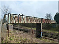
Railway bridge LTN1/185, Kelvedon
A steel footbridge that could do with a little more graffiti, if Network Rail aren't going to bother to protect the steel. Only the far span crosses tracks now, the near span once crossed tracks into the goods yard, now gone.
Image: © Robin Webster
Taken: 15 Feb 2015
0.03 miles
2
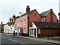
131 - 139 (odds) High Street, Kelvedon
A grade II listed row of late 18th century cottages, some since converted to shops and, at the far end, a pub, but now they all seem to have reverted to cottages. The pub was The George.
Image: © Robin Webster
Taken: 15 Feb 2015
0.10 miles
3
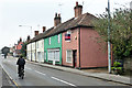
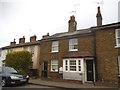
113 - 119 (odds) High Street, Kelvedon
113 - 117 (odds), the far light coloured buildings, are grade II listed from around 1600, altered later. 119, the pink building, is 17th century, altered later, and also grade II listed along with its railings. The estate agents is 121 High Street.
Image: © Robin Webster
Taken: 15 Feb 2015
0.11 miles
4
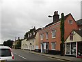
Houses in Kelvedon High Street
Seen from the corner of St Mary's Road. Plenty of Georgian details - including unusual bracketed hood-moulds on the pink house - but in places like Kelvedon, Georgian façades were often applied to older, timber-framed buildings. The gambrel-roofed building (with three dormers) certainly looks older.
Image: © Stefan Czapski
Taken: 5 Sep 2015
0.12 miles
6
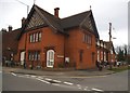
Mary's House, Kelvedon
This is what looks like an old church building which was converted into housing in 1992
Image: © David Howard
Taken: 4 Apr 2017
0.12 miles
7
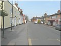
Looking northeast along Kelvedon High Street
Image: © John Baker
Taken: 28 Mar 2014
0.12 miles
8
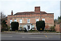
Ormonde House, High Street, Kelvedon
A grade II listed building of 16th century origin, altered over the years.
Image: © Robin Webster
Taken: 15 Feb 2015
0.13 miles
9
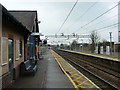
On Kelvedon station
On the up platform looking in the up direction, next station Witham. The station building is a modern replacement. The tracks are now signalled for bi-directional running. Kelvedon Crossovers, facing crossovers with a 50 mph limit, are either side of the next bridge in this direction.
Image: © Robin Webster
Taken: 15 Feb 2015
0.13 miles
10
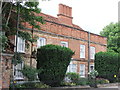
Ormonde House, High Street, Kelvedon
This is a 16th or early 17th century timber framed house with a 18th century brick front
Image: © PAUL FARMER
Taken: 13 Jun 2010
0.13 miles