IMAGES TAKEN NEAR TO
The Seedfield, COLCHESTER, CO5 8UD
Introduction
This page details the photographs taken nearby to The Seedfield, CO5 8UD by members of the Geograph project.
The Geograph project started in 2005 with the aim of publishing, organising and preserving representative images for every square kilometre of Great Britain, Ireland and the Isle of Man.

There are currently over 7.5m images from over14,400 individuals and you can help contribute to the project by visiting https://www.geograph.org.uk
Image Map (Loading...)


Getting Data...Please wait
Leaflet Map data © OpenStreetMap
Images are licensed for reuse under creativecommons.org/licenses/by-sa/2.0
Notes
- Clicking on the map will re-center to the selected point.
- The higher the marker number, the further away the image location is from the centre of the postcode.
Image Listing (111 Images Found)
Images are licensed for reuse under creativecommons.org/licenses/by-sa/2.0
Image
Details
Distance
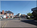
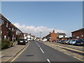
1
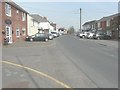
Looking north along the High Street (B1029)
Image: © John Baker
Taken: 2 Apr 2014
0.11 miles
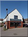
5
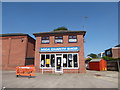
The Mersea Clipper
Hairdresser in access road to car park from High Street
Image: © John Firth
Taken: 14 Sep 2010
0.12 miles
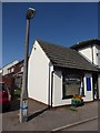
7
Standing by the library, looking across the High Street
Image: © Basher Eyre
Taken: 17 Jul 2020
0.13 miles
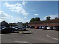
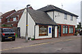
8
B1025 High Street, West Mersea
Near The Mersea Centre
Image: © Geographer
Taken: 3 Oct 2015
0.13 miles
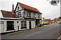
9
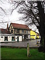
The White Hart
The White Hart pub is situated diagonally across the church of St Peter and Paul, on High Street, West Mersea.
Image: © Evelyn Simak
Taken: 15 Jan 2008
0.13 miles