IMAGES TAKEN NEAR TO
Constable Close, COLCHESTER, CO5 8RX
Introduction
This page details the photographs taken nearby to Constable Close, CO5 8RX by members of the Geograph project.
The Geograph project started in 2005 with the aim of publishing, organising and preserving representative images for every square kilometre of Great Britain, Ireland and the Isle of Man.

There are currently over 7.5m images from over14,400 individuals and you can help contribute to the project by visiting https://www.geograph.org.uk
Image Map
Images are licensed for reuse under creativecommons.org/licenses/by-sa/2.0
Notes
- Clicking on the map will re-center to the selected point.
- The higher the marker number, the further away the image location is from the centre of the postcode.
Image Listing (49 Images Found)
Images are licensed for reuse under creativecommons.org/licenses/by-sa/2.0
Image
Details
Distance
1
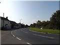
B1025 Colchester Road, West Mersea
Near West Mersea Playing Field
Image: © Geographer
Taken: 3 Oct 2015
0.06 miles
4
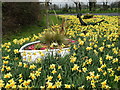
West Mersea Daffodils - by Colchester Road
Image: © Neil Theasby
Taken: 8 Apr 2015
0.07 miles
5
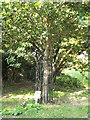
Mersea Millennium Oak
Off the B1025 Colchester Road
Image: © Geographer
Taken: 3 Oct 2015
0.08 miles
6
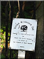
Plaque with Mersea Millennium Oak
Off the B1025 Colchester Road
(Close up)
Image: © Geographer
Taken: 3 Oct 2015
0.08 miles
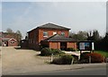
7
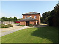
West Mersea Free Church
Off the B1025 Mill Road
Image: © Geographer
Taken: 3 Oct 2015
0.08 miles
8
B1025 Mill Road, West Mersea
At the junction with Colchester Road & B1025 Colchester Road
Image: © Geographer
Taken: 3 Oct 2015
0.08 miles
9
Entrance to West Mersea Playing Field
Off the B1025 Colchester Road
Image: © Geographer
Taken: 3 Oct 2015
0.08 miles
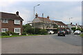
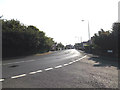
10

Colchester Road at the junction of Mill Road
Image: © David Howard
Taken: 6 Jun 2021
0.09 miles