IMAGES TAKEN NEAR TO
Pine Grove, COLCHESTER, CO5 8PZ
Introduction
This page details the photographs taken nearby to Pine Grove, CO5 8PZ by members of the Geograph project.
The Geograph project started in 2005 with the aim of publishing, organising and preserving representative images for every square kilometre of Great Britain, Ireland and the Isle of Man.

There are currently over 7.5m images from over14,400 individuals and you can help contribute to the project by visiting https://www.geograph.org.uk
Image Map
Images are licensed for reuse under creativecommons.org/licenses/by-sa/2.0
Notes
- Clicking on the map will re-center to the selected point.
- The higher the marker number, the further away the image location is from the centre of the postcode.
Image Listing (21 Images Found)
Images are licensed for reuse under creativecommons.org/licenses/by-sa/2.0
Image
Details
Distance
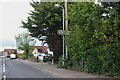
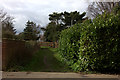
1
Upland Road, West Mersea
Directly ahead is the footpath that leads to Firs Chase.
Image: © Robert Eva
Taken: 21 Feb 2017
0.04 miles
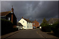
5
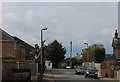
Houses on High Street North, West Mersea
Image: © Robin Webster
Taken: 28 Nov 2017
0.12 miles
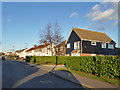
6
Bridleway off Woodfield Drive
This path leads to Firs Grove
Image: © Robert Eva
Taken: 21 Feb 2017
0.14 miles
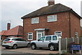
7
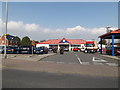
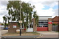
Tesco Express, West Mersea
Off the B1025 Barfield Road at the junction with High Street North
http://www.tesco.com/store-locator/uk/?bID=5465
Image: © Geographer
Taken: 3 Oct 2015
0.15 miles