IMAGES TAKEN NEAR TO
Stonehill Way, COLCHESTER, CO5 8NQ
Introduction
This page details the photographs taken nearby to Stonehill Way, CO5 8NQ by members of the Geograph project.
The Geograph project started in 2005 with the aim of publishing, organising and preserving representative images for every square kilometre of Great Britain, Ireland and the Isle of Man.

There are currently over 7.5m images from over14,400 individuals and you can help contribute to the project by visiting https://www.geograph.org.uk
Image Map (Loading...)


Getting Data...Please wait
Leaflet Map data © OpenStreetMap
Images are licensed for reuse under creativecommons.org/licenses/by-sa/2.0
Notes
- Clicking on the map will re-center to the selected point.
- The higher the marker number, the further away the image location is from the centre of the postcode.
Image Listing (65 Images Found)
Images are licensed for reuse under creativecommons.org/licenses/by-sa/2.0
Image
Details
Distance
1
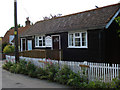
The Old City Hall West Mersea
This tiny chapel was built in about 1930 on the site of The Old Ship public house on the instructions of the Miss Plumers, Ann and Ruth of Seaview Avenue. In 1940 it was handed over to a group of local Christians with no conditions attached. (Information from westmersea.org)
Image: © Phil Gaskin
Taken: 20 May 2009
0.11 miles
2
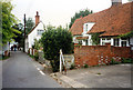
The Lane, West Mersea
Right centre with the dormer is Grade II Listed Anchor Cottage dated around 1575. Left centre the white weatherboarded Bluebird Cottage is also Grade II listed and dates from late 18th or early 19th century.
Image: © Jo and Steve Turner
Taken: 22 Sep 1996
0.12 miles
3
The Lane, West Mersea
The Grade II Listed Little Timbers of 18th century origin is the cottage with mansard roof on the right slightly forward of the weatherboarded cottage.
Image: © Jo and Steve Turner
Taken: 22 Sep 1996
0.12 miles
4
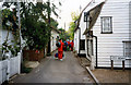
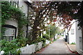
Old houses in The Lane
This narrow road, called The Lane, has many old houses that were once fisherman's cottages.
Image: © Robert Edwards
Taken: 27 Feb 2008
0.13 miles
5
The Lane, West Mersea
A narrow street lined with old fishermen's cottages; some at least date back to the 17th Century.
Image: © Trevor Harris
Taken: 30 Oct 2009
0.13 miles
6
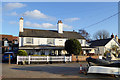
The Old Victory, West Mersea
A mid 19th century grade II listed building, listed in 1982 as two houses with no reference to it ever being a pub. On Victorian maps it indeed was The Victory pub. The licence was transferred to the new Victory up the road in 1907.
Image: © Robin Webster
Taken: 28 Nov 2017
0.15 miles
7
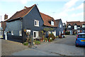
Smugglers Way, West Mersea
A late medieval grade II listed house. I had to look twice at this, as the rest of Carriers Close looks new build but in a similar style.
Image: © Robin Webster
Taken: 28 Nov 2017
0.16 miles
8
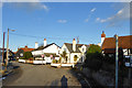
Coast Road, West Mersea
Here running behind boatyards off to the left.
Image: © Robin Webster
Taken: 28 Nov 2017
0.16 miles
9
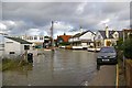
High Tide Near Dabchicks Sailing Club
Looking towards "The Lane" in West Mersea
Image: © Glyn Baker
Taken: 21 Jan 2007
0.16 miles
10
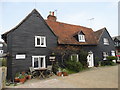
Smugglers' Way
Traditional house in West Mersea
Image: © Neil Theasby
Taken: 8 Apr 2015
0.16 miles