IMAGES TAKEN NEAR TO
Layer Road, COLCHESTER, CO5 7NL
Introduction
This page details the photographs taken nearby to Layer Road, CO5 7NL by members of the Geograph project.
The Geograph project started in 2005 with the aim of publishing, organising and preserving representative images for every square kilometre of Great Britain, Ireland and the Isle of Man.

There are currently over 7.5m images from over14,400 individuals and you can help contribute to the project by visiting https://www.geograph.org.uk
Image Map
Images are licensed for reuse under creativecommons.org/licenses/by-sa/2.0
Notes
- Clicking on the map will re-center to the selected point.
- The higher the marker number, the further away the image location is from the centre of the postcode.
Image Listing (21 Images Found)
Images are licensed for reuse under creativecommons.org/licenses/by-sa/2.0
Image
Details
Distance
1
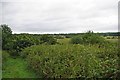
Footpath to Friday Wood
This footpath goes from Oxley Hill down the Roman River valley and then on to Friday Wood.
Image: © Glyn Baker
Taken: 19 Jul 2009
0.10 miles
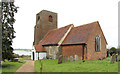
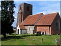
3
St Andrew's church, Abberton
C14 nave, chancel C19 on C14 foundations, tower is C16.
Image: © Bikeboy
Taken: 13 Sep 2014
0.21 miles
5
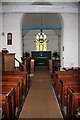
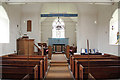
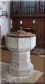
Abberton Church interior
The interior of St Andrew's Church is very simple, but the blue rood beam is highly decorated.
Image: © Bob Jones
Taken: 11 Nov 2008
0.21 miles

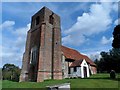
9
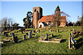
St Andrew's Church, Abberton
This church stands high above Abberton Reservoir, with the churchyard sloping down towards the banks of the reservoir.
Image: © Bob Jones
Taken: 11 Nov 2008
0.22 miles
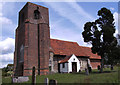
10
St Andrew's church, Abberton
C14 nave, chancel C19 on C14 foundations, tower is C16.
Image: © Bikeboy
Taken: 13 Sep 2014
0.22 miles