IMAGES TAKEN NEAR TO
Lodge Lane, COLCHESTER, CO5 7LX
Introduction
This page details the photographs taken nearby to Lodge Lane, CO5 7LX by members of the Geograph project.
The Geograph project started in 2005 with the aim of publishing, organising and preserving representative images for every square kilometre of Great Britain, Ireland and the Isle of Man.

There are currently over 7.5m images from over14,400 individuals and you can help contribute to the project by visiting https://www.geograph.org.uk
Image Map
Images are licensed for reuse under creativecommons.org/licenses/by-sa/2.0
Notes
- Clicking on the map will re-center to the selected point.
- The higher the marker number, the further away the image location is from the centre of the postcode.
Image Listing (6 Images Found)
Images are licensed for reuse under creativecommons.org/licenses/by-sa/2.0
Image
Details
Distance
2

Range Control
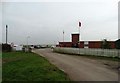
The main observation and admin building on Image
Image: © Glyn Baker
Taken: 4 Aug 2013
0.03 miles
4
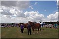
The Five Parishes Show
Each Year for the past 81 years the Five Parishes Horticultural Society has put on a country show. For many years it has been held on the Image by permission of the Commander Defence Training Estate East. The Five Parishes are Abberton, Little Wigborough, Peldon, Great Wigborough & Langenhoe. This is the main arena with Suffolk Punches giving a display. Suffolk Punches are on the Rare Breeds Survival Trust's https://www.rbst.org.uk/ critically endangered list there less than fifty breeding mares and only a hand full of stallions left in the U.K http://www.suffolkpunchtrust.org/
Image: © Glyn Baker
Taken: 4 Aug 2013
0.09 miles
5
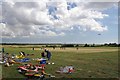
Range & Radio Models
Colchester Model Aircraft Club http://www.webjam.com/colchestermac_intro/about_us giving a flying demo at Image on Image
Image: © Glyn Baker
Taken: 4 Aug 2013
0.21 miles
6
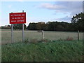
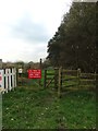
Sign near entrance to Fingrinhoe Range next to Lodge Lane
Image: © PAUL FARMER
Taken: 6 Nov 2010
0.21 miles