IMAGES TAKEN NEAR TO
Haye Lane, COLCHESTER, CO5 7AD
Introduction
This page details the photographs taken nearby to Haye Lane, CO5 7AD by members of the Geograph project.
The Geograph project started in 2005 with the aim of publishing, organising and preserving representative images for every square kilometre of Great Britain, Ireland and the Isle of Man.

There are currently over 7.5m images from over14,400 individuals and you can help contribute to the project by visiting https://www.geograph.org.uk
Image Map
Images are licensed for reuse under creativecommons.org/licenses/by-sa/2.0
Notes
- Clicking on the map will re-center to the selected point.
- The higher the marker number, the further away the image location is from the centre of the postcode.
Image Listing (6 Images Found)
Images are licensed for reuse under creativecommons.org/licenses/by-sa/2.0
Image
Details
Distance
1
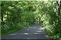
Haye Lane, Abberton
A lane north of the village of Abberton.
Image: © Trevor Harris
Taken: 26 May 2023
0.09 miles
2
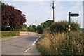
Haye Lane
Haye Lane Fingringhoe at the junction of the Byway to Upper Haye Farm and the footpath to Hay farm
Image: © Glyn Baker
Taken: 2 Jul 2006
0.12 miles
3
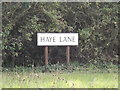
Haye Lane sign
On Haye Lane at the junction with the B1025 Mersea Road
Image: © Geographer
Taken: 3 Oct 2015
0.15 miles
4
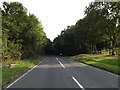
Haye Lane, Abberton
At the junction with the B1025 Mersea Road
Image: © Geographer
Taken: 3 Oct 2015
0.15 miles
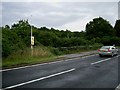
5

B1025 Mersea Road, Abberton
At the junction with Haye Lane
Image: © Geographer
Taken: 3 Oct 2015
0.15 miles
6
Flagpole by Manwood Bridge
The flagpole flies a red flag when the middlewick range Image is in use. Enter the woods at your peril. Manwood bridge carries the B1025 over Roman River.
Image: © Glyn Baker
Taken: 13 Aug 2005
0.18 miles