IMAGES TAKEN NEAR TO
Knights Close, COLCHESTER, CO5 0RL
Introduction
This page details the photographs taken nearby to Knights Close, CO5 0RL by members of the Geograph project.
The Geograph project started in 2005 with the aim of publishing, organising and preserving representative images for every square kilometre of Great Britain, Ireland and the Isle of Man.

There are currently over 7.5m images from over14,400 individuals and you can help contribute to the project by visiting https://www.geograph.org.uk
Image Map
Images are licensed for reuse under creativecommons.org/licenses/by-sa/2.0
Notes
- Clicking on the map will re-center to the selected point.
- The higher the marker number, the further away the image location is from the centre of the postcode.
Image Listing (7 Images Found)
Images are licensed for reuse under creativecommons.org/licenses/by-sa/2.0
Image
Details
Distance
1
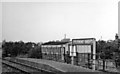
Tolleshunt Knights Halt, 1950
View NW, towards Kelvedon: Kelvedon & Tollesbury Light Railway (ex-GER), closed 7/5/51.
Image: © Walter Dendy, deceased
Taken: 7 Aug 1950
0.07 miles

3
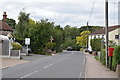
D'Arcy Road, Tolleshunt Knights
Looking towards Factory Hill.
Image: © Trevor Harris
Taken: 31 Aug 2020
0.13 miles
4
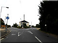
B1023 Factory Hill, Tolleshunt Knights
At the junction with the B1023 D'Arcy Road & Brook Road
Image: © Geographer
Taken: 10 Aug 2016
0.13 miles
5
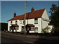
'Rose & Crown' inn at Tolleshunt Knights, Essex
The road in the photo is the B.1023
Image: © Robert Edwards
Taken: 20 Oct 2006
0.16 miles
6

Tolleshunt Knights Village Name sign
On the B1023 Factory Hill
Image: © Geographer
Taken: 10 Sep 2016
0.23 miles
7
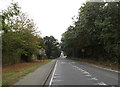
Entering Tolleshunt Knights on the B1023 Factory Hill
Image: © Geographer
Taken: 10 Sep 2016
0.23 miles