IMAGES TAKEN NEAR TO
Almond Close, COLCHESTER, CO5 0NY
Introduction
This page details the photographs taken nearby to Almond Close, CO5 0NY by members of the Geograph project.
The Geograph project started in 2005 with the aim of publishing, organising and preserving representative images for every square kilometre of Great Britain, Ireland and the Isle of Man.

There are currently over 7.5m images from over14,400 individuals and you can help contribute to the project by visiting https://www.geograph.org.uk
Image Map
Images are licensed for reuse under creativecommons.org/licenses/by-sa/2.0
Notes
- Clicking on the map will re-center to the selected point.
- The higher the marker number, the further away the image location is from the centre of the postcode.
Image Listing (29 Images Found)
Images are licensed for reuse under creativecommons.org/licenses/by-sa/2.0
Image
Details
Distance
1
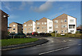
Walnut Tree Way, Tiptree
A modern residential street off Maypole Road.
Image: © Andrew Hill
Taken: 5 Dec 2009
0.05 miles
2
Houses on Maypole Road, Tiptree
Modern houses by the B1022 road to Colchester.
Image: © Andrew Hill
Taken: 5 Dec 2009
0.08 miles
3

Shell petrol station on Maypole Road, Tiptree
My earlier visit. https://www.geograph.org.uk/photo/5338300
Image: © David Howard
Taken: 27 Oct 2024
0.12 miles
4
Maypole Road, Tiptree
By an open area just north of the busy junction with a double mini-roundabout. This is the B1022 towards Colchester.
Image: © Andrew Hill
Taken: 5 Dec 2009
0.12 miles
5
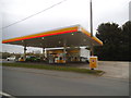
Shell petrol station on Maypole Road, Tiptree
Image: © David Howard
Taken: 4 Apr 2017
0.12 miles
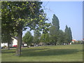
7

Lombardy Poplar tree
This is a Lombardy Poplar (Poplus nigra) standing around 55 metres tall.
Image: © Lewis Potter
Taken: 25 Apr 2011
0.14 miles
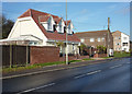
8
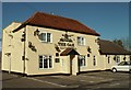
'The Oak' inn, Oak Road, Tiptree, Essex
Image: © Robert Edwards
Taken: 20 Oct 2006
0.14 miles
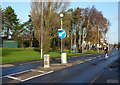
9
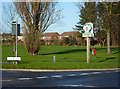
Green and Tiptree sign
The sign is by a busy junction at the edge of a green. It does of course feature a picture depicting a link with the jam making industry.
Image: © Andrew Hill
Taken: 5 Dec 2009
0.16 miles
10
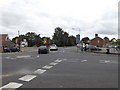
B1022 Maldon Road, Tiptree
At the junction with the B1023 Kelvedon Road, B1022 Maypole Road & B1023 Church Road
Image: © Geographer
Taken: 10 Sep 2016
0.16 miles