IMAGES TAKEN NEAR TO
Newbridge Road, COLCHESTER, CO5 0HS
Introduction
This page details the photographs taken nearby to Newbridge Road, CO5 0HS by members of the Geograph project.
The Geograph project started in 2005 with the aim of publishing, organising and preserving representative images for every square kilometre of Great Britain, Ireland and the Isle of Man.

There are currently over 7.5m images from over14,400 individuals and you can help contribute to the project by visiting https://www.geograph.org.uk
Image Map
Images are licensed for reuse under creativecommons.org/licenses/by-sa/2.0
Notes
- Clicking on the map will re-center to the selected point.
- The higher the marker number, the further away the image location is from the centre of the postcode.
Image Listing (9 Images Found)
Images are licensed for reuse under creativecommons.org/licenses/by-sa/2.0
Image
Details
Distance
1
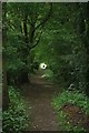
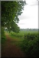
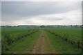
Footpath to Tolleshunt Knights
For much of its length this footpath runs parallel with Image either side of Paternoster Heath
Image: © Glyn Baker
Taken: 7 May 2011
0.11 miles
2
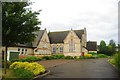
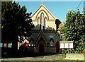
Tiptree URC
The back entrance of Tiptree United Reformed Church
Image: © Glyn Baker
Taken: 7 May 2011
0.11 miles
4
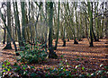
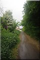
Wood at the edge of Tiptree
The path is close to the edge of the town here.
Image: © Andrew Hill
Taken: 5 Dec 2009
0.13 miles
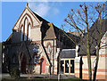
5
Tiptree United Reformed Church, Tiptree, Essex
Image: © Robert Edwards
Taken: 20 Oct 2006
0.17 miles
6
Towards Paternoster Heath
A little further along Image
Image: © Glyn Baker
Taken: 7 May 2011
0.18 miles
7
End of the Bridleway
This is the end of the bridleway from Tolleshunt Knights
Image: © Glyn Baker
Taken: 7 May 2011
0.19 miles
8
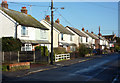
Houses on Chapel Road, Tiptree
Semi-detached houses line this residential street.
Image: © Andrew Hill
Taken: 5 Dec 2009
0.21 miles
9
New Hedge
In a few years this footpath will be delineated by a hawthorn hedge
Image: © Glyn Baker
Taken: 7 May 2011
0.25 miles