IMAGES TAKEN NEAR TO
Church Road, COLCHESTER, CO5 0HB
Introduction
This page details the photographs taken nearby to Church Road, CO5 0HB by members of the Geograph project.
The Geograph project started in 2005 with the aim of publishing, organising and preserving representative images for every square kilometre of Great Britain, Ireland and the Isle of Man.

There are currently over 7.5m images from over14,400 individuals and you can help contribute to the project by visiting https://www.geograph.org.uk
Image Map (Loading...)


Getting Data...Please wait
Leaflet Map data © OpenStreetMap
Images are licensed for reuse under creativecommons.org/licenses/by-sa/2.0
Notes
- Clicking on the map will re-center to the selected point.
- The higher the marker number, the further away the image location is from the centre of the postcode.
Image Listing (19 Images Found)
Images are licensed for reuse under creativecommons.org/licenses/by-sa/2.0
Image
Details
Distance
1
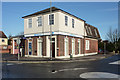
Barclays Bank, Tiptree
On the corner of Church Road and New Road.
Image: © Andrew Hill
Taken: 5 Dec 2009
0.07 miles
2
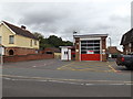
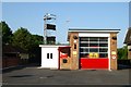
Tiptree Fire Station
Off the B1023 Church Road
Image: © Geographer
Taken: 10 Sep 2016
0.07 miles
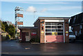
3
Tiptree fire station
Tiptree fire station, 63 Church Road, Tiptree, Colchester, Essex
Image: © Kevin Hale
Taken: 4 Jun 2010
0.07 miles
4
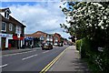
Church Road, Tiptree
From the junction with Chapel Road
Image: © John Myers
Taken: 16 May 2015
0.07 miles
5
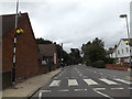
B1023 Church Road, Tiptree
Near Tiptree Fire Station
Image: © Geographer
Taken: 10 Sep 2016
0.07 miles
6
Tiptree fire station
On Church Road by the bank at the corner of New Road.
Image: © Andrew Hill
Taken: 5 Dec 2009
0.08 miles
8
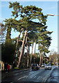
Pine trees along Church Road
Streetside pine trees in Tiptree either side of the junction of Rectory Road.
Image: © Andrew Hill
Taken: 5 Dec 2009
0.14 miles