IMAGES TAKEN NEAR TO
Coriander Road, COLCHESTER, CO5 0AU
Introduction
This page details the photographs taken nearby to Coriander Road, CO5 0AU by members of the Geograph project.
The Geograph project started in 2005 with the aim of publishing, organising and preserving representative images for every square kilometre of Great Britain, Ireland and the Isle of Man.

There are currently over 7.5m images from over14,400 individuals and you can help contribute to the project by visiting https://www.geograph.org.uk
Image Map (Loading...)


Getting Data...Please wait
Leaflet Map data © OpenStreetMap
Images are licensed for reuse under creativecommons.org/licenses/by-sa/2.0
Notes
- Clicking on the map will re-center to the selected point.
- The higher the marker number, the further away the image location is from the centre of the postcode.
Image Listing (14 Images Found)
Images are licensed for reuse under creativecommons.org/licenses/by-sa/2.0
Image
Details
Distance
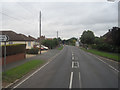
2
Houses, Anchor Road, Tiptree
Looking along a residential street of the town.
Image: © Andrew Hill
Taken: 5 Dec 2009
0.11 miles
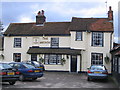
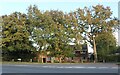
3
The Anchor PH, Station Road, Tiptree, Essex
Image: © Peter Stack
Taken: 17 Aug 2010
0.11 miles
4
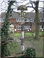
Direction Sign ? Signpost on Spring Road, Tiptree
Located on the west side of Spring Road just south of it junction with the B1022 Maldon Road in Tiptree parish. 3 missing arms and half-moon finial. Whether or not this is in its original location is unknown. The single sided finial reads INWORTH but at some date a plate with TIPTREE was bolted to it to cover the original legend. The plate has now virtually rusted away.
Milestone Society National ID: EX_TL8915
Image: © John V Nicholls
Taken: Unknown
0.14 miles
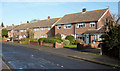
5
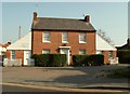
An old cottage at the end of Surrey Lane
This is where Surrey Lane meets Station Road. There are many houses around Station Road and this is one of the older ones.
Image: © Robert Edwards
Taken: 7 May 2008
0.14 miles
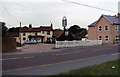
6
Spring Road, Tiptree
At the junction of Maldon Road
Image: © David Howard
Taken: 27 Oct 2024
0.14 miles
8
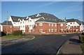
Rosemary Court
A large new development of flats for the over 50's in the corner of Rectory Road and Rosemary Crescent. From the map it looks as though it is infilling a formerly open area. Looking across a gridline.
Image: © Andrew Hill
Taken: 5 Dec 2009
0.17 miles
9
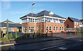
Office space, Station Road, Tiptree
Smart modern offices to let.
Image: © Andrew Hill
Taken: 5 Dec 2009
0.18 miles