IMAGES TAKEN NEAR TO
Enville Way, COLCHESTER, CO4 9UF
Introduction
This page details the photographs taken nearby to Enville Way, CO4 9UF by members of the Geograph project.
The Geograph project started in 2005 with the aim of publishing, organising and preserving representative images for every square kilometre of Great Britain, Ireland and the Isle of Man.

There are currently over 7.5m images from over14,400 individuals and you can help contribute to the project by visiting https://www.geograph.org.uk
Image Map
Images are licensed for reuse under creativecommons.org/licenses/by-sa/2.0
Notes
- Clicking on the map will re-center to the selected point.
- The higher the marker number, the further away the image location is from the centre of the postcode.
Image Listing (7 Images Found)
Images are licensed for reuse under creativecommons.org/licenses/by-sa/2.0
Image
Details
Distance
2

The Gilberd School
Comprehensive School named after William Gilberd, the pioneer of the study of magnetism in England. He lived in Trinity Street, Colchester.
Image: © Angela Tuff
Taken: 24 Jan 2006
0.13 miles
3
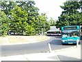
A busy morning at the Highwoods bus terminus, Highwoods Sq, Colchester
Buses of Arriva and First Bus stacked up in Highwoods Square.
Image: © Peter Pearson
Taken: 18 Aug 2016
0.19 miles
4
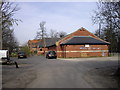
St Johns and Highwoods Community Centre, Colchester
The community Centre is located in Highwoods Square.
Image: © PAUL FARMER
Taken: 24 Apr 2010
0.20 miles
6
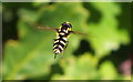
Hoverfly (Xanthogramma pedissequum)
There is no English name for this hoverfly.
Photographed in a wooded area off Tescos car park at Highwoods, Colchester, it was taking advantage of one of the few sunny days last year.
Image: © Peter Pearson
Taken: 15 Jul 2012
0.24 miles
7

Eastwood Drive under construction
The field to the left is where Victoria Gardens is today
Image: © Mr James D
Taken: 14 Nov 1987
0.25 miles