IMAGES TAKEN NEAR TO
Pampas Close, COLCHESTER, CO4 9ST
Introduction
This page details the photographs taken nearby to Pampas Close, CO4 9ST by members of the Geograph project.
The Geograph project started in 2005 with the aim of publishing, organising and preserving representative images for every square kilometre of Great Britain, Ireland and the Isle of Man.

There are currently over 7.5m images from over14,400 individuals and you can help contribute to the project by visiting https://www.geograph.org.uk
Image Map
Images are licensed for reuse under creativecommons.org/licenses/by-sa/2.0
Notes
- Clicking on the map will re-center to the selected point.
- The higher the marker number, the further away the image location is from the centre of the postcode.
Image Listing (14 Images Found)
Images are licensed for reuse under creativecommons.org/licenses/by-sa/2.0
Image
Details
Distance
1

Eastwood Drive under construction
The field to the left is where Victoria Gardens is today
Image: © Mr James D
Taken: 14 Nov 1987
0.13 miles
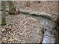
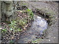
4
Meander in Stream 11
Slowly but surely Highwoods Stream flows south.
Image: © Lewis Potter
Taken: 6 Feb 2011
0.19 miles
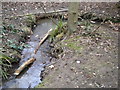
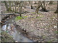
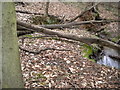
7
Meander in stream 6
Crossing the 35 contour line.
Image: © Lewis Potter
Taken: 6 Feb 2011
0.20 miles
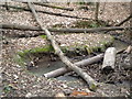
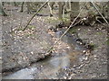
8
Meander in stream 8
The full turn, shown in the top of photo 7 http://www.geograph.org.uk/photo/2259755.
Image: © Lewis Potter
Taken: 6 Feb 2011
0.20 miles
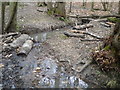
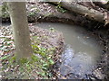
9
Meander in stream 13: The Grande Bend
The biggest bend flowing from right to left.
Image: © Lewis Potter
Taken: 6 Feb 2011
0.20 miles