IMAGES TAKEN NEAR TO
The Seedbed Centre, Wyncolls Road, COLCHESTER, CO4 9HT
Introduction
This page details the photographs taken nearby to The Seedbed Centre, Wyncolls Road, CO4 9HT by members of the Geograph project.
The Geograph project started in 2005 with the aim of publishing, organising and preserving representative images for every square kilometre of Great Britain, Ireland and the Isle of Man.

There are currently over 7.5m images from over14,400 individuals and you can help contribute to the project by visiting https://www.geograph.org.uk
Image Map
Images are licensed for reuse under creativecommons.org/licenses/by-sa/2.0
Notes
- Clicking on the map will re-center to the selected point.
- The higher the marker number, the further away the image location is from the centre of the postcode.
Image Listing (3 Images Found)
Images are licensed for reuse under creativecommons.org/licenses/by-sa/2.0
Image
Details
Distance
1
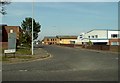
Clough Road
This is a small part of a large Business Park that is situated on the northern outskirts of Colchester.
Image: © Robert Edwards
Taken: 5 May 2008
0.08 miles
2
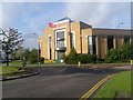
Essex House, The Crescent, Colchester Business Park
Image: © David Gearing
Taken: 20 Oct 2006
0.09 miles
3
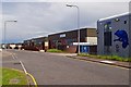
Brunel Way
This is Brunel Way part of a large business park to the north of Colchester. The mainly service industries based here have to some degree helped alleviate the unemployment caused by the closure of Colchester’s traditional engineering employers such as the lathe company.
Image: © Glyn Baker
Taken: 29 May 2006
0.09 miles