IMAGES TAKEN NEAR TO
CO4 6ET
Introduction
This page details the photographs taken nearby to CO4 6ET by members of the Geograph project.
The Geograph project started in 2005 with the aim of publishing, organising and preserving representative images for every square kilometre of Great Britain, Ireland and the Isle of Man.

There are currently over 7.5m images from over14,400 individuals and you can help contribute to the project by visiting https://www.geograph.org.uk
Image Map
Images are licensed for reuse under creativecommons.org/licenses/by-sa/2.0
Notes
- Clicking on the map will re-center to the selected point.
- The higher the marker number, the further away the image location is from the centre of the postcode.
Image Listing (13 Images Found)
Images are licensed for reuse under creativecommons.org/licenses/by-sa/2.0
Image
Details
Distance
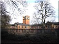
3
Severalls Hospital
This is a derelict part of Severalls Hospital Colchester. A 19th century asylum it expanded through the 20th century and is now contracting fast with developers keen to cash in on the valuable land.
Image: © Glyn Baker
Taken: 22 Jul 2006
0.14 miles
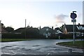
5
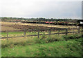
Cants of Colchester Rose fields
Adjacent to A134 just south of by-pass
Image: © John Firth
Taken: 14 Sep 2010
0.22 miles
6
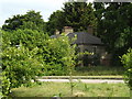
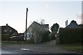
Orchard Cottage on Tower Lane
Taken from United Way near Western Homes Community Stadium
Image: © Geographer
Taken: 28 Jun 2015
0.23 miles
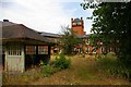
7
Water tower at Severalls Hospital Colchester
The hospital has been closed for over 10 years and is largly unused and secured
Image: © PAUL FARMER
Taken: 12 Dec 2009
0.23 miles
9
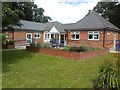
The Headway Centre, Severalls Hospital
Image: © Alex McGregor
Taken: 9 Jun 2011
0.23 miles
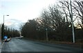
10
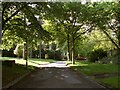
Part of the grounds of Severalls Hospital
Image: © Robert Edwards
Taken: 9 Jun 2008
0.23 miles