IMAGES TAKEN NEAR TO
Charter Way, COLCHESTER, CO4 6EB
Introduction
This page details the photographs taken nearby to Charter Way, CO4 6EB by members of the Geograph project.
The Geograph project started in 2005 with the aim of publishing, organising and preserving representative images for every square kilometre of Great Britain, Ireland and the Isle of Man.

There are currently over 7.5m images from over14,400 individuals and you can help contribute to the project by visiting https://www.geograph.org.uk
Image Map
Images are licensed for reuse under creativecommons.org/licenses/by-sa/2.0
Notes
- Clicking on the map will re-center to the selected point.
- The higher the marker number, the further away the image location is from the centre of the postcode.
Image Listing (16 Images Found)
Images are licensed for reuse under creativecommons.org/licenses/by-sa/2.0
Image
Details
Distance
1

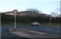
Conifers by Via Urbis Romanae, Mile End
Image: © David Howard
Taken: 6 Feb 2022
0.10 miles
2

Colchester General Hospital
This is Colchester General Hospital, The queen graciously declined the offer of having it named after her …….I can’t think why! ;-)
Image: © Glyn Baker
Taken: 5 Mar 2006
0.12 miles
3
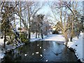
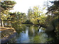
Partly frozen lake outside Colchester General Hospital
Image: © PAUL FARMER
Taken: 19 Dec 2009
0.12 miles
4
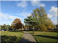
Path to the car parks, Colchester General Hospital
An area of grass with a few trees and a pond acts as a cordon sanitaire between the car parks and the hospital buildings.
Image: © Jonathan Thacker
Taken: 7 Nov 2016
0.12 miles
5
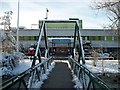
Colchester General Hospital Main entrance
Colchester General Hospital was opened in 1985 by the Queen
Image: © PAUL FARMER
Taken: 19 Dec 2009
0.13 miles
6
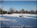
Snow covered grounds outside Colchester General Hospital
Image: © PAUL FARMER
Taken: 19 Dec 2009
0.13 miles
7
Ornamental pond, Colchester General Hospital
Acts as a sort of moat between the car parks and the hospital buildings.
Image: © Jonathan Thacker
Taken: 7 Nov 2016
0.14 miles
8
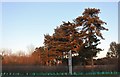
Via Urbis Romanae at the junction of Dickenson Road
Image: © David Howard
Taken: 6 Feb 2022
0.17 miles
10
Via Urbis Romanae, Mile End
Colchester is Britain's oldest town (according to the signs), and a Roman centre. Although this not a straight road it has the Latin name of the Roman road.
Image: © David Howard
Taken: 23 Feb 2019
0.20 miles