IMAGES TAKEN NEAR TO
Lilianna Road, COLCHESTER, CO4 6DN
Introduction
This page details the photographs taken nearby to Lilianna Road, CO4 6DN by members of the Geograph project.
The Geograph project started in 2005 with the aim of publishing, organising and preserving representative images for every square kilometre of Great Britain, Ireland and the Isle of Man.

There are currently over 7.5m images from over14,400 individuals and you can help contribute to the project by visiting https://www.geograph.org.uk
Image Map
Images are licensed for reuse under creativecommons.org/licenses/by-sa/2.0
Notes
- Clicking on the map will re-center to the selected point.
- The higher the marker number, the further away the image location is from the centre of the postcode.
Image Listing (9 Images Found)
Images are licensed for reuse under creativecommons.org/licenses/by-sa/2.0
Image
Details
Distance


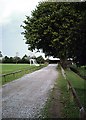
3
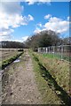
Ford's Lane
Looking towards Colchester Golf Club (behind the tree line).
Image: © Glyn Baker
Taken: 7 Mar 2019
0.15 miles
4

Towards Cordelia Drive
A new development called "Chesterwell" by Mersea Homes
Image: © Glyn Baker
Taken: 7 Mar 2019
0.15 miles
5
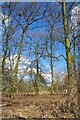
Old Trees and New Fence
I assume the fence is something to do with the new Chesterwell housing development.
Image: © Glyn Baker
Taken: 7 Mar 2019
0.16 miles
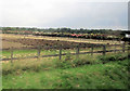
8
Mile End Recreational Ground, Colchester
Track from car-park to Ford Lane.
Image: © John Myers
Taken: 1 Oct 2006
0.22 miles
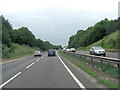
9
Cants of Colchester Rose fields
Adjacent to A134 just south of by-pass
Image: © John Firth
Taken: 14 Sep 2010
0.25 miles