IMAGES TAKEN NEAR TO
Wheelwright Place, COLCHESTER, CO4 5ZF
Introduction
This page details the photographs taken nearby to Wheelwright Place, CO4 5ZF by members of the Geograph project.
The Geograph project started in 2005 with the aim of publishing, organising and preserving representative images for every square kilometre of Great Britain, Ireland and the Isle of Man.

There are currently over 7.5m images from over14,400 individuals and you can help contribute to the project by visiting https://www.geograph.org.uk
Image Map
Images are licensed for reuse under creativecommons.org/licenses/by-sa/2.0
Notes
- Clicking on the map will re-center to the selected point.
- The higher the marker number, the further away the image location is from the centre of the postcode.
Image Listing (15 Images Found)
Images are licensed for reuse under creativecommons.org/licenses/by-sa/2.0
Image
Details
Distance
1
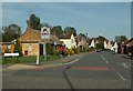
Looking down Defoe Crescent from Nayland Road
Image: © Robert Edwards
Taken: 5 May 2008
0.04 miles
2
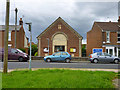
Methodist Church, Mile End, Colchester
On a part of Nayland Road now only a through route for buses and taxis since a bypass was built.
Image: © Robin Webster
Taken: 2 Jul 2016
0.05 miles
3
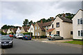
Houses on Defoe Crescent, Mile End
The road is used by bus route 2.
Image: © Robin Webster
Taken: 2 Jul 2016
0.06 miles
4
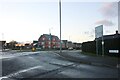
Boxted Road at the junction of Wildeve Avenue
The flats were built around 2016
Image: © David Howard
Taken: 6 Feb 2022
0.12 miles
5
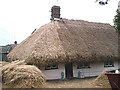
Thatching in progress, Mile End.
Thatched cottage with "Beatle" haircut awaiting final trim. In Nayland Road.
Image: © John Myers
Taken: 1 Oct 2006
0.12 miles
9
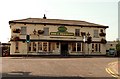
'Dog & Pheasant' public house, Mile End, Essex
This pub stands alongside part of the original A.134 road, but this section has now been bypassed by a new road.
Image: © Robert Edwards
Taken: 11 Sep 2006
0.18 miles
10
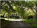
Part of the grounds of Severalls Hospital
Image: © Robert Edwards
Taken: 9 Jun 2008
0.21 miles