IMAGES TAKEN NEAR TO
Venture Chase, COLCHESTER, CO4 5YW
Introduction
This page details the photographs taken nearby to Venture Chase, CO4 5YW by members of the Geograph project.
The Geograph project started in 2005 with the aim of publishing, organising and preserving representative images for every square kilometre of Great Britain, Ireland and the Isle of Man.

There are currently over 7.5m images from over14,400 individuals and you can help contribute to the project by visiting https://www.geograph.org.uk
Image Map
Images are licensed for reuse under creativecommons.org/licenses/by-sa/2.0
Notes
- Clicking on the map will re-center to the selected point.
- The higher the marker number, the further away the image location is from the centre of the postcode.
Image Listing (18 Images Found)
Images are licensed for reuse under creativecommons.org/licenses/by-sa/2.0
Image
Details
Distance
1
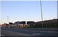
New houses on Via Urbis Romanae
These houses were built in 2016, and unusually made in the modern style, which on my travels appears a very rare design since the 90s. Many blocks of flats are built this way but nearly all houses in the last 30 years have been faux Victorian or older styles.
Image: © David Howard
Taken: 23 Feb 2019
0.14 miles
3
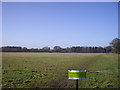
Private Land near Mill Road Colchester
The building in the distance is the water tower of the former Severalls Hospital
Image: © PAUL FARMER
Taken: 6 Feb 2010
0.15 miles
4

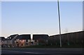
Via Urbis Romanae, Mile End
By pure chance I got here the moment people were leaving the stadium car park on the left at Colchester FC who had just finished their match. At least I now know where the stadium is and I can park there if I ever want to go in the future and they got them out fairly quickly as it is controlled by stewards.
Image: © David Howard
Taken: 23 Feb 2019
0.17 miles
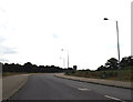
6
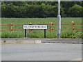
Via Urbis Romanae sign
On Via Urbis Romanae at Stadium Roundabout at the junction with United Way & Axial Way
Image: © Geographer
Taken: 28 Jun 2015
0.21 miles
7
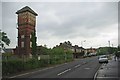
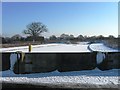
Mill Road Water Tower
The water tower used to serve the Myland Hospital that before WW2 was an isolation hospital for TB and other infectious diseases. It was deemed to be far enough outside of the town as to not pose a health risk to the general population. The hospital was still in use in the 1970's. This is the only trace of the hospital that remains and by the look of it this too is due for demolition quite soon.
Image: © Glyn Baker
Taken: 8 May 2011
0.21 miles
8
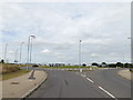
United Way, Mile End, Colchester
At Stadium Roundabout
Image: © Geographer
Taken: 28 Jun 2015
0.21 miles
9
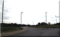
United Way, Mile End, Colchester
At Stadium Roundabout at the junction with Via Urbis Romanae & Axial Way
Image: © Geographer
Taken: 28 Jun 2015
0.22 miles
10
United Way, Mile End, Colchester
At Stadium Roundabout at the junction with Via Urbis Romanae & Axial Way
Image: © Geographer
Taken: 28 Jun 2015
0.22 miles