IMAGES TAKEN NEAR TO
Whitehouse Close, COLCHESTER, CO4 5XF
Introduction
This page details the photographs taken nearby to Whitehouse Close, CO4 5XF by members of the Geograph project.
The Geograph project started in 2005 with the aim of publishing, organising and preserving representative images for every square kilometre of Great Britain, Ireland and the Isle of Man.

There are currently over 7.5m images from over14,400 individuals and you can help contribute to the project by visiting https://www.geograph.org.uk
Image Map
Images are licensed for reuse under creativecommons.org/licenses/by-sa/2.0
Notes
- Clicking on the map will re-center to the selected point.
- The higher the marker number, the further away the image location is from the centre of the postcode.
Image Listing (2 Images Found)
Images are licensed for reuse under creativecommons.org/licenses/by-sa/2.0
Image
Details
Distance
1
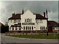
'Shepherd & Dog' public house, Langham, Essex
This is now the only remaining pub in Langham. It stands on the corner of Moor Road and High Street and was built in 1928.
Image: © Robert Edwards
Taken: 20 Apr 2006
0.06 miles
2
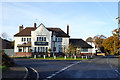
The Shepherd, Langham
Crossed shepherd's crooks on the gable. Formerly the Shepherd and Dog.
Image: © Robin Webster
Taken: 19 Nov 2017
0.07 miles