IMAGES TAKEN NEAR TO
Peto Avenue, COLCHESTER, CO4 5WL
Introduction
This page details the photographs taken nearby to Peto Avenue, CO4 5WL by members of the Geograph project.
The Geograph project started in 2005 with the aim of publishing, organising and preserving representative images for every square kilometre of Great Britain, Ireland and the Isle of Man.

There are currently over 7.5m images from over14,400 individuals and you can help contribute to the project by visiting https://www.geograph.org.uk
Image Map
Images are licensed for reuse under creativecommons.org/licenses/by-sa/2.0
Notes
- Clicking on the map will re-center to the selected point.
- The higher the marker number, the further away the image location is from the centre of the postcode.
Image Listing (9 Images Found)
Images are licensed for reuse under creativecommons.org/licenses/by-sa/2.0
Image
Details
Distance
2
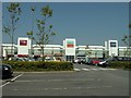
Car Park-Turner Rise Retail Park
Petrolea Close
Image: © PAUL FARMER
Taken: 21 Mar 2009
0.08 miles
3
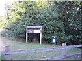
Turner Rise South sign, Highwoods Country Park
Image: © PAUL FARMER
Taken: 10 Jul 2010
0.09 miles
4
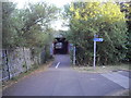
Footpath junction in Highwoods Country Park
Image: © PAUL FARMER
Taken: 10 Jul 2010
0.10 miles
5
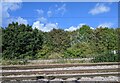
Joining train tracks entering Colchester
Image: © Roy Hughes
Taken: 14 Oct 2023
0.18 miles
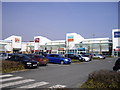
6

ASDA superstore Colchester
Off Northern Approach road roundabout
Image: © John Firth
Taken: 14 Sep 2010
0.23 miles
7
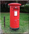
Elizabeth II postbox on Mason Road, Colchester
Postbox No. CO1 30.
See Image] for context.
Image: © JThomas
Taken: 24 Apr 2017
0.23 miles

9
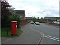
Mason Road, Colchester
Showing position of Postbox No. CO1 30.
See Image] for postbox.
Image: © JThomas
Taken: 24 Apr 2017
0.24 miles