IMAGES TAKEN NEAR TO
De Grey Road, COLCHESTER, CO4 5TZ
Introduction
This page details the photographs taken nearby to De Grey Road, CO4 5TZ by members of the Geograph project.
The Geograph project started in 2005 with the aim of publishing, organising and preserving representative images for every square kilometre of Great Britain, Ireland and the Isle of Man.

There are currently over 7.5m images from over14,400 individuals and you can help contribute to the project by visiting https://www.geograph.org.uk
Image Map
Images are licensed for reuse under creativecommons.org/licenses/by-sa/2.0
Notes
- Clicking on the map will re-center to the selected point.
- The higher the marker number, the further away the image location is from the centre of the postcode.
Image Listing (18 Images Found)
Images are licensed for reuse under creativecommons.org/licenses/by-sa/2.0
Image
Details
Distance
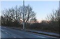
2
Upgraded Path
This path beside the A12 has been upgraded from a footpath to a bridleway
Image: © Glyn Baker
Taken: 8 May 2011
0.10 miles
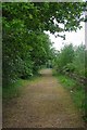
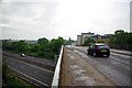
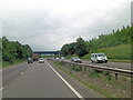
3
Several Ways
The flyover carries Severalls Lane over the A12 and the Bridleway turns to the left and continues parallel to the A12 for some distance.
Image: © Glyn Baker
Taken: 8 May 2011
0.11 miles
4
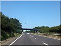
A12 westbound with Severalls Lane bridge
And one pigeon!
Image: © David Smith
Taken: 21 Jun 2014
0.11 miles
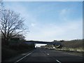
5
A12 & Severalls Lane
The Severalls Lane Flyover the A12.
Image: © Glyn Baker
Taken: 8 May 2011
0.11 miles
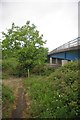
7
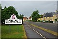
Mill Road, Myland
This area of Colchester has been built up considerably over the past ten to fifteen years.
Image: © Glyn Baker
Taken: 8 May 2011
0.12 miles
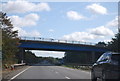
10
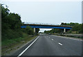
A12 Ipswich Road & Severalls Lane bridge
Image: © Geographer
Taken: 1 Sep 2013
0.12 miles