IMAGES TAKEN NEAR TO
Boxted, COLCHESTER, CO4 5TJ
Introduction
This page details the photographs taken nearby to CO4 5TJ by members of the Geograph project.
The Geograph project started in 2005 with the aim of publishing, organising and preserving representative images for every square kilometre of Great Britain, Ireland and the Isle of Man.

There are currently over 7.5m images from over14,400 individuals and you can help contribute to the project by visiting https://www.geograph.org.uk
Image Map
Images are licensed for reuse under creativecommons.org/licenses/by-sa/2.0
Notes
- Clicking on the map will re-center to the selected point.
- The higher the marker number, the further away the image location is from the centre of the postcode.
Image Listing (10 Images Found)
Images are licensed for reuse under creativecommons.org/licenses/by-sa/2.0
Image
Details
Distance
2
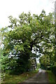
Part of the Essex Way public footpath
This part of the footpath is also the approach to Boxted Hall.
Image: © Robert Edwards
Taken: 5 May 2008
0.05 miles
3
The Essex Way at Boxted Hall
This is Boxted Footpath #1; it comes out in Church Street.
Image: © Glyn Baker
Taken: 5 May 2023
0.07 miles
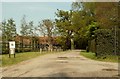
4
Holly Hedge at Boxted Hall
Looking towards the village.
Image: © Glyn Baker
Taken: 5 May 2023
0.10 miles
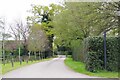
5
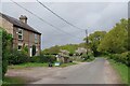
Houses at the Top of Burnt Dick Hill
In the outskirts of Boxted.
Image: © Glyn Baker
Taken: 5 May 2023
0.14 miles
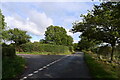
6
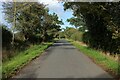
Burnt Dick Hill
Quiet lane adopted by the Essex Way for a short duration
Image: © Chris Heaton
Taken: 15 Oct 2020
0.17 miles
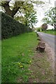
9
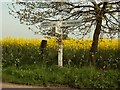
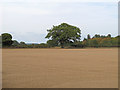
A signpost at Boxted
A picture of a signpost is not normally interesting, but having a field of rape in the background can make a difference. This is at the junction of Church Road and Burnt Dick Hill.
Image: © Robert Edwards
Taken: 5 May 2008
0.22 miles
10
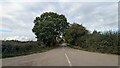
Burnt Dick Hill leading off Church Road
How does 'Burnt Dick Hill' get its name?
Image: © Tim Heaton
Taken: 15 Oct 2020
0.22 miles