IMAGES TAKEN NEAR TO
Skye Hall Hill, COLCHESTER, CO4 5TD
Introduction
This page details the photographs taken nearby to Skye Hall Hill, CO4 5TD by members of the Geograph project.
The Geograph project started in 2005 with the aim of publishing, organising and preserving representative images for every square kilometre of Great Britain, Ireland and the Isle of Man.

There are currently over 7.5m images from over14,400 individuals and you can help contribute to the project by visiting https://www.geograph.org.uk
Image Map
Images are licensed for reuse under creativecommons.org/licenses/by-sa/2.0
Notes
- Clicking on the map will re-center to the selected point.
- The higher the marker number, the further away the image location is from the centre of the postcode.
Image Listing (7 Images Found)
Images are licensed for reuse under creativecommons.org/licenses/by-sa/2.0
Image
Details
Distance
1
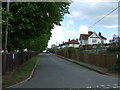
Looking east from Sky Hall Hill
Beside the water works.
Image: © JThomas
Taken: 25 Apr 2017
0.02 miles
2
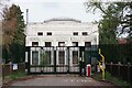
Langham Water Treatment Works
The Art Deco structure does a fair impression of Fort Knox!
Image: © Glyn Baker
Taken: 6 May 2023
0.05 miles
3
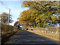
High Lift Villas Road
A straightening of an earlier lane, its name, along with the 'Villas' further along, probably to do with the building of a big waterworks on the right.
Image: © Robin Webster
Taken: 19 Nov 2017
0.08 miles
4
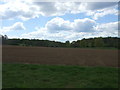
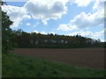
Field near Valley Farm
West of Sky Hall Hill.
Image: © JThomas
Taken: 25 Apr 2017
0.10 miles
6
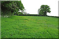
Footpath along wood near Plumb's Farm, Boxted
Image: © Roger Jones
Taken: 30 May 2015
0.17 miles
7
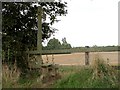
Stile at Sky Hall Hill, close to Boxted, Essex
Image: © Robert Edwards
Taken: 9 Oct 2006
0.20 miles