IMAGES TAKEN NEAR TO
Lower Farm Road, COLCHESTER, CO4 5SZ
Introduction
This page details the photographs taken nearby to Lower Farm Road, CO4 5SZ by members of the Geograph project.
The Geograph project started in 2005 with the aim of publishing, organising and preserving representative images for every square kilometre of Great Britain, Ireland and the Isle of Man.

There are currently over 7.5m images from over14,400 individuals and you can help contribute to the project by visiting https://www.geograph.org.uk
Image Map
Images are licensed for reuse under creativecommons.org/licenses/by-sa/2.0
Notes
- Clicking on the map will re-center to the selected point.
- The higher the marker number, the further away the image location is from the centre of the postcode.
Image Listing (12 Images Found)
Images are licensed for reuse under creativecommons.org/licenses/by-sa/2.0
Image
Details
Distance
1
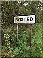
Boxted Village Name sign
On Lower Farm Road
Image: © Geographer
Taken: 16 Aug 2014
0.03 miles
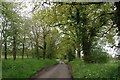
4
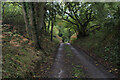
Essex Way in Cophedge Wood
The long distance footpath changes direction for a little while - heading south through woods towards Rivers Hall.
Image: © Chris Heaton
Taken: 15 Oct 2020
0.04 miles
5
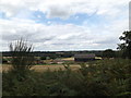
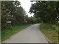
Looking towards Lower Farm
Off Lower Farm Road
Image: © Geographer
Taken: 16 Aug 2014
0.05 miles
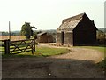
8
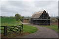
Lower Farm Road
Looking towards Lower Farm.
Image: © Glyn Baker
Taken: 6 May 2023
0.17 miles
9
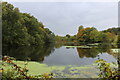
Lake in Woodland below Rivers Hall
Passed by on the Essex Way long distance footpath
Image: © Chris Heaton
Taken: 15 Oct 2020
0.19 miles
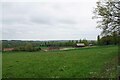
10
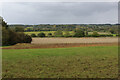
A View over the Stour Valley
A reminder that the Essex Way is now entering Constable Country - the photograph taken from Church Street in the scattered community of Boxted.
Image: © Chris Heaton
Taken: 15 Oct 2020
0.22 miles