IMAGES TAKEN NEAR TO
Red House Lane, COLCHESTER, CO4 5RL
Introduction
This page details the photographs taken nearby to Red House Lane, CO4 5RL by members of the Geograph project.
The Geograph project started in 2005 with the aim of publishing, organising and preserving representative images for every square kilometre of Great Britain, Ireland and the Isle of Man.

There are currently over 7.5m images from over14,400 individuals and you can help contribute to the project by visiting https://www.geograph.org.uk
Image Map
Images are licensed for reuse under creativecommons.org/licenses/by-sa/2.0
Notes
- Clicking on the map will re-center to the selected point.
- The higher the marker number, the further away the image location is from the centre of the postcode.
Image Listing (3 Images Found)
Images are licensed for reuse under creativecommons.org/licenses/by-sa/2.0
Image
Details
Distance
2
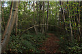
Essex Way in Harrow Wood
The long distance footpath twists and turns as it heads through this small patch of woodland
Image: © Chris Heaton
Taken: 15 Oct 2020
0.21 miles
3
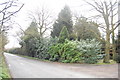
The Essex Way 121
The path emerges from woodland to reach this road.
Image: © Trevor Harris
Taken: 13 Mar 2011
0.23 miles