IMAGES TAKEN NEAR TO
Langham, COLCHESTER, CO4 5QB
Introduction
This page details the photographs taken nearby to CO4 5QB by members of the Geograph project.
The Geograph project started in 2005 with the aim of publishing, organising and preserving representative images for every square kilometre of Great Britain, Ireland and the Isle of Man.

There are currently over 7.5m images from over14,400 individuals and you can help contribute to the project by visiting https://www.geograph.org.uk
Image Map
Images are licensed for reuse under creativecommons.org/licenses/by-sa/2.0
Notes
- Clicking on the map will re-center to the selected point.
- The higher the marker number, the further away the image location is from the centre of the postcode.
Image Listing (14 Images Found)
Images are licensed for reuse under creativecommons.org/licenses/by-sa/2.0
Image
Details
Distance
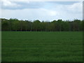
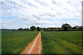
1
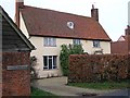
Docura's Farm
Looking across the verdant winter cereal.
Image: © Glyn Baker
Taken: 4 May 2023
0.02 miles
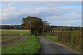
3
Bend in the road near Docura's Farm
Looking east.
Image: © JThomas
Taken: 25 Apr 2017
0.09 miles
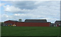
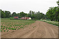
4

Towards West Lodge
The lane that leads from a Image
Image: © Glyn Baker
Taken: 4 May 2023
0.12 miles
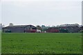
6
Looking along arable field margin towards West Lodge, Langham
Image: © Roger Jones
Taken: 25 May 2015
0.12 miles
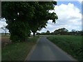
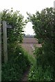
7
Quiet Lane in the Scattered Community of Langham
Crossed by the Essex Way long distance footpath
Image: © Chris Heaton
Taken: 15 Oct 2020
0.13 miles
8
Footpath #3 Langham
Image starts in Stratford St Mary and ends in a junction with Boxted path #15 and Langham #18 a few hundred metres from here.
Image: © Glyn Baker
Taken: 4 May 2023
0.15 miles
9
The Essex Way 130
South of Docura's Farm, the Essex Way crosses a field of young wheat.
Image: © Trevor Harris
Taken: 8 May 2011
0.15 miles