IMAGES TAKEN NEAR TO
Turnpike Close, COLCHESTER, CO4 5NG
Introduction
This page details the photographs taken nearby to Turnpike Close, CO4 5NG by members of the Geograph project.
The Geograph project started in 2005 with the aim of publishing, organising and preserving representative images for every square kilometre of Great Britain, Ireland and the Isle of Man.

There are currently over 7.5m images from over14,400 individuals and you can help contribute to the project by visiting https://www.geograph.org.uk
Image Map
Images are licensed for reuse under creativecommons.org/licenses/by-sa/2.0
Notes
- Clicking on the map will re-center to the selected point.
- The higher the marker number, the further away the image location is from the centre of the postcode.
Image Listing (11 Images Found)
Images are licensed for reuse under creativecommons.org/licenses/by-sa/2.0
Image
Details
Distance
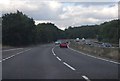
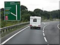
2
Slip road onto A12 northbound from A120
Image: © David Smith
Taken: 30 May 2017
0.17 miles
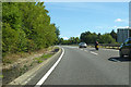
3
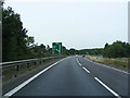
A12 Ipswich Road, Fox Street
Approaching junction 29 Ardleigh Crown
Image: © Geographer
Taken: 1 Sep 2013
0.21 miles
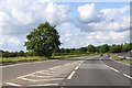
4
Joining the A12 at Ardleigh Crown Junction
Image: © David Dixon
Taken: 2 Aug 2013
0.23 miles
5
Langham Trig
This triangulation point is near Langham Lodge farm. If satellite imaging had not rendered triangulation points obsolete some lumberjacking would be required before this one could be used again!
Image: © Glyn Baker
Taken: 30 Sep 2006
0.23 miles
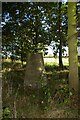
6

Old Milepost
Old milepost near to Langham, Essex. For close up view see http://www.geograph.org.uk/photo/2622026
Image: © Keith Evans
Taken: 28 Sep 2011
0.23 miles
7

To London 55
Old milepost near to Langham, Essex. For overall view see http://www.geograph.org.uk/photo/2622024
Image: © Keith Evans
Taken: 28 Sep 2011
0.24 miles
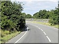
8
A12 Ipswich Road at Junction 29 (Ardleigh Crown)
Image: © David Dixon
Taken: 2 Aug 2013
0.24 miles
10

Old Milestone by the former A12, Blue Barns Farm
Carved stone post by the UC road (was A12), in parish of Ardleigh (Tendring District), 240m South of Harts Lane, by garage, on East side of road. Erected by the Chelmsford (Div of Essex First Dist) turnpike trust in the 19th century.
Inscription reads:-
: Ardleigh : : London : : ?Colchester V :
Grade II listed.
List entry number: 1147792 https://historicengland.org.uk/listing/the-list/list-entry/1147792
Essex HER.
SMR Number: 15743 https://www.heritagegateway.org.uk/Gateway/Results_Single.aspx?uid=MEX1009948&resourceID=1001
Milestone Society National ID: EX_COIP55
Image: © Alan Rosevear
Taken: Unknown
0.24 miles