IMAGES TAKEN NEAR TO
Langham Lane, COLCHESTER, CO4 5HX
Introduction
This page details the photographs taken nearby to Langham Lane, CO4 5HX by members of the Geograph project.
The Geograph project started in 2005 with the aim of publishing, organising and preserving representative images for every square kilometre of Great Britain, Ireland and the Isle of Man.

There are currently over 7.5m images from over14,400 individuals and you can help contribute to the project by visiting https://www.geograph.org.uk
Image Map
Images are licensed for reuse under creativecommons.org/licenses/by-sa/2.0
Notes
- Clicking on the map will re-center to the selected point.
- The higher the marker number, the further away the image location is from the centre of the postcode.
Image Listing (3 Images Found)
Images are licensed for reuse under creativecommons.org/licenses/by-sa/2.0
Image
Details
Distance
1
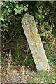
Old Boundary Marker off Langham Lane, Langham
MOD Boundary Marker southeast of Langham Lane, at the entrance to Boxted Airfield Museum, on the former Boxted airfield. Langham parish. While the airfield was used from 1943 to 1947, the Royal Observer Corps post was used from 1961 to 1991 and the marker will date after 1964. Reference https://www.subbrit.org.uk/sites/langham-roc-post/.
Milestone Society National ID: EX_MODLAN01em
Image: © M Bardell
Taken: 11 Sep 2021
0.07 miles
2
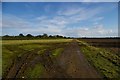
Boxted Airfield
This shows what appears to be part of a dispersal and the remains of the perimeter track of the former Boxted airfield in the parish of Langham north of Colchester. Using the normal naming convention this would have been Langham Airfield but there was already an RAF station of that name in Norfolk. The station was operational from May 1943 until November 1947. Various USAAF fighter and bomber groups operated from here. When the field was finally stood down the RAF fighter command were operating Meteor jets from the base. You can see the remains of the main runway at Image, there is a memorial at Image To go to the next field in an alphabetical tour of Essex WW2 airfields click on Image Much information was gleaned from Graham Smith’s book “Essex Airfields In The Second World War”. https://books.google.co.uk/books/about/Essex_Airfields_in_the_Second_World_War.html?id=u3atAAAACAAJ&redir_esc=y
Image: © Glyn Baker
Taken: 30 Sep 2006
0.09 miles
3
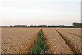
Footpath through wheat field, off Langham Lane, Langham
Image: © Roger Jones
Taken: 8 Aug 2015
0.12 miles