IMAGES TAKEN NEAR TO
Peppers Lane, COLCHESTER, CO4 5HL
Introduction
This page details the photographs taken nearby to Peppers Lane, CO4 5HL by members of the Geograph project.
The Geograph project started in 2005 with the aim of publishing, organising and preserving representative images for every square kilometre of Great Britain, Ireland and the Isle of Man.

There are currently over 7.5m images from over14,400 individuals and you can help contribute to the project by visiting https://www.geograph.org.uk
Image Map
Images are licensed for reuse under creativecommons.org/licenses/by-sa/2.0
Notes
- Clicking on the map will re-center to the selected point.
- The higher the marker number, the further away the image location is from the centre of the postcode.
Image Listing (5 Images Found)
Images are licensed for reuse under creativecommons.org/licenses/by-sa/2.0
Image
Details
Distance
1
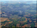
Colchester from the air
Looking south from a Stansted bound flight from Prague. Colchester United FC's stadium at Cuckoo Farm can be seen just below the centre of the photo.
Image: © Thomas Nugent
Taken: 7 Sep 2012
0.08 miles
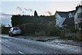
4
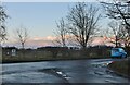
Langham Road at the junction of Straight Road
Image: © David Howard
Taken: 6 Feb 2022
0.10 miles