IMAGES TAKEN NEAR TO
Straight Road, COLCHESTER, CO4 5HJ
Introduction
This page details the photographs taken nearby to Straight Road, CO4 5HJ by members of the Geograph project.
The Geograph project started in 2005 with the aim of publishing, organising and preserving representative images for every square kilometre of Great Britain, Ireland and the Isle of Man.

There are currently over 7.5m images from over14,400 individuals and you can help contribute to the project by visiting https://www.geograph.org.uk
Image Map
Images are licensed for reuse under creativecommons.org/licenses/by-sa/2.0
Notes
- Clicking on the map will re-center to the selected point.
- The higher the marker number, the further away the image location is from the centre of the postcode.
Image Listing (9 Images Found)
Images are licensed for reuse under creativecommons.org/licenses/by-sa/2.0
Image
Details
Distance
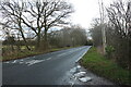
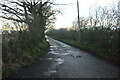
1
Field and woods by Straight Road, Horkesley Heath
Image: © David Howard
Taken: 6 Feb 2022
0.11 miles
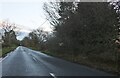
2
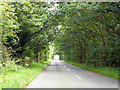
Horkesley Road
Heading towards a junction with Straight Road.
Image: © Robin Webster
Taken: 16 Jul 2016
0.15 miles
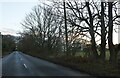
3
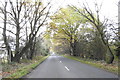
Avenue of semi-naked trees in Ivy Lodge Road
Image: © Adrian S Pye
Taken: 21 Nov 2019
0.16 miles
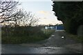
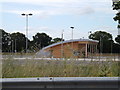
8
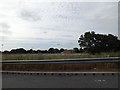
Colchester Park & Ride
Off Cuckoo Farm Way near the Services
Opened Monday 13th April 2015.
http://www.essexhighways.org/Transport-and-Roads/Highway-Schemes-and-Developments/Major-Schemes/Colchester-Park-and-Ride.aspx
Image: © Geographer
Taken: 28 Jun 2015
0.25 miles
9
Colchester Park & Ride
Off Cuckoo Farm Way near the Services
Opened Monday 13th April 2015.
http://www.essexhighways.org/Transport-and-Roads/Highway-Schemes-and-Developments/Major-Schemes/Colchester-Park-and-Ride.aspx
(Close up)
Image: © Geographer
Taken: 28 Jun 2015
0.25 miles