IMAGES TAKEN NEAR TO
Jade Gardens, COLCHESTER, CO4 5FG
Introduction
This page details the photographs taken nearby to Jade Gardens, CO4 5FG by members of the Geograph project.
The Geograph project started in 2005 with the aim of publishing, organising and preserving representative images for every square kilometre of Great Britain, Ireland and the Isle of Man.

There are currently over 7.5m images from over14,400 individuals and you can help contribute to the project by visiting https://www.geograph.org.uk
Image Map
Images are licensed for reuse under creativecommons.org/licenses/by-sa/2.0
Notes
- Clicking on the map will re-center to the selected point.
- The higher the marker number, the further away the image location is from the centre of the postcode.
Image Listing (7 Images Found)
Images are licensed for reuse under creativecommons.org/licenses/by-sa/2.0
Image
Details
Distance
1
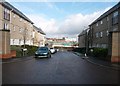
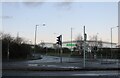
Wallace Road, Colchester
Looking east towards Turner Road and the new development.
Image: © MJ Reilly
Taken: 12 Mar 2010
0.07 miles
2
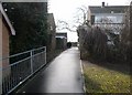
Play area, Bradford Drive, Colchester
Fenced off playground
Image: © MJ Reilly
Taken: 12 Mar 2010
0.17 miles
3
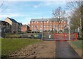
Footpath to the hospital, Hakewill Way, Colchester
Path across the Northern Approach Road
Image: © MJ Reilly
Taken: 12 Mar 2010
0.18 miles
4
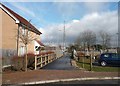
Footpath to Tall Trees, Colchester
Path from Hakewill Way
Image: © MJ Reilly
Taken: 12 Mar 2010
0.22 miles
5

Car Park-Turner Rise Retail Park
Petrolea Close
Image: © PAUL FARMER
Taken: 21 Mar 2009
0.23 miles
6
Asda Superstore on Turner Road, Colchester
Image: © David Howard
Taken: 6 Feb 2022
0.24 miles